|
|
|||||||||||||||||
| Point ID: 6521 | Downloads | Plots | Site Data | Code: 8356 |
|
|
|||||||||||||||||
| Download | |
|---|---|
| Site Descriptor Information | Site Time Series Data |
| Link to all available data | |
| View: | Time Series | All |
| Units: | m3/s |
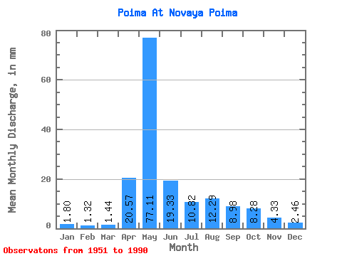
| Statistic | Jan | Feb | Mar | Apr | May | Jun | Jul | Aug | Sep | Oct | Nov | Dec | Annual |
|---|---|---|---|---|---|---|---|---|---|---|---|---|---|
| Mean | 1.80 | 1.33 | 1.44 | 20.57 | 77.09 | 19.33 | 10.82 | 12.29 | 8.98 | 8.28 | 4.33 | 2.46 | 167.81 |
| Standard Deviation | 0.71 | 0.57 | 0.66 | 18.85 | 33.52 | 9.44 | 5.05 | 13.65 | 8.84 | 4.80 | 2.25 | 1.01 | 53.47 |
| Min | 0.67 | 0.38 | 0.33 | 1.49 | 20.39 | 6.91 | 4.66 | 2.56 | 1.86 | 2.77 | 1.78 | 1.00 | 63.99 |
| Max | 3.25 | 2.91 | 3.00 | 69.30 | 172.56 | 43.38 | 25.77 | 59.84 | 58.35 | 24.20 | 12.04 | 4.66 | 291.90 |
| Coefficient of Variation | 0.40 | 0.43 | 0.46 | 0.92 | 0.43 | 0.49 | 0.47 | 1.11 | 0.98 | 0.58 | 0.52 | 0.41 | 0.32 |
 Return to R-Arctic Net Home Page