|
|
|||||||||||||||||
| Point ID: 6353 | Downloads | Plots | Site Data | Code: 3871 |
|
|
|||||||||||||||||
| Download | |
|---|---|
| Site Descriptor Information | Site Time Series Data |
| Link to all available data | |
| View: | Time Series | All |
| Units: | m3/s |
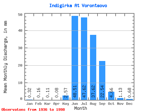
| Statistic | Jan | Feb | Mar | Apr | May | Jun | Jul | Aug | Sep | Oct | Nov | Dec | Annual |
|---|---|---|---|---|---|---|---|---|---|---|---|---|---|
| Mean | 0.32 | 0.16 | 0.11 | 0.08 | 2.57 | 48.51 | 47.61 | 37.62 | 22.54 | 4.66 | 1.13 | 0.68 | 164.54 |
| Standard Deviation | 0.09 | 0.06 | 0.05 | 0.04 | 3.73 | 13.92 | 12.73 | 12.88 | 8.97 | 1.89 | 0.29 | 0.19 | 33.52 |
| Min | 0.16 | 0.09 | 0.03 | 0.03 | 0.05 | 16.91 | 22.17 | 18.35 | 9.94 | 1.89 | 0.70 | 0.39 | 103.86 |
| Max | 0.63 | 0.50 | 0.42 | 0.29 | 17.39 | 90.08 | 75.33 | 84.69 | 50.16 | 12.59 | 2.08 | 1.26 | 261.49 |
| Coefficient of Variation | 0.29 | 0.38 | 0.47 | 0.55 | 1.45 | 0.29 | 0.27 | 0.34 | 0.40 | 0.41 | 0.26 | 0.27 | 0.20 |
 Return to R-Arctic Net Home Page