|
|
|||||||||||||||||
| Point ID: 6250 | Downloads | Plots | Site Data | Code: 3277 |
|
|
|||||||||||||||||
| Download | |
|---|---|
| Site Descriptor Information | Site Time Series Data |
| Link to all available data | |
| View: | Time Series | All |
| Units: | m3/s |
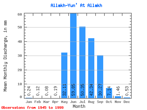
| Statistic | Jan | Feb | Mar | Apr | May | Jun | Jul | Aug | Sep | Oct | Nov | Dec | Annual |
|---|---|---|---|---|---|---|---|---|---|---|---|---|---|
| Mean | 0.24 | 0.12 | 0.08 | 0.19 | 32.11 | 59.85 | 50.35 | 42.34 | 30.27 | 7.13 | 1.46 | 0.54 | 223.65 |
| Standard Deviation | 0.19 | 0.10 | 0.07 | 0.53 | 19.00 | 31.47 | 23.88 | 22.45 | 15.59 | 3.27 | 0.61 | 0.36 | 70.77 |
| Min | 0.02 | 0.01 | 0.00 | 0.01 | 3.23 | 15.21 | 18.81 | 11.95 | 9.13 | 2.19 | 0.46 | 0.13 | 88.69 |
| Max | 0.95 | 0.38 | 0.35 | 3.62 | 104.24 | 133.88 | 119.51 | 115.09 | 78.51 | 15.38 | 3.83 | 2.08 | 456.94 |
| Coefficient of Variation | 0.78 | 0.80 | 0.89 | 2.79 | 0.59 | 0.53 | 0.47 | 0.53 | 0.52 | 0.46 | 0.41 | 0.67 | 0.32 |
 Return to R-Arctic Net Home Page