|
|
|||||||||||||||||
| Point ID: 6247 | Downloads | Plots | Site Data | Code: 3271 |
|
|
|||||||||||||||||
| Download | |
|---|---|
| Site Descriptor Information | Site Time Series Data |
| Link to all available data | |
| View: | Time Series | All |
| Units: | m3/s |
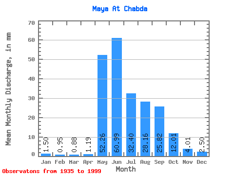
| Statistic | Jan | Feb | Mar | Apr | May | Jun | Jul | Aug | Sep | Oct | Nov | Dec | Annual |
|---|---|---|---|---|---|---|---|---|---|---|---|---|---|
| Mean | 1.50 | 0.96 | 0.88 | 1.20 | 52.26 | 60.99 | 32.40 | 28.16 | 25.82 | 12.01 | 4.01 | 2.50 | 221.77 |
| Standard Deviation | 0.43 | 0.28 | 0.27 | 1.17 | 19.58 | 25.69 | 13.65 | 13.64 | 11.48 | 5.49 | 1.23 | 0.71 | 53.08 |
| Min | 0.58 | 0.46 | 0.39 | 0.40 | 11.59 | 18.38 | 12.72 | 8.73 | 10.35 | 5.13 | 2.01 | 1.31 | 108.39 |
| Max | 2.31 | 1.75 | 1.92 | 9.44 | 100.79 | 139.81 | 73.36 | 72.39 | 57.97 | 26.13 | 7.37 | 4.27 | 372.16 |
| Coefficient of Variation | 0.29 | 0.29 | 0.31 | 0.98 | 0.38 | 0.42 | 0.42 | 0.48 | 0.45 | 0.46 | 0.30 | 0.28 | 0.24 |
 Return to R-Arctic Net Home Page