|
|
| Point ID: 7013 | Downloads | Plots | Site Data | Other Close Sites | Code: 11315 |
|
| Download | |
|---|---|
| Site Descriptor Information | Site Time Series Data |
| Link to all available data | |
|
|
|
| View: | Statistics | All |
| Units: | mm |
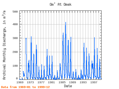
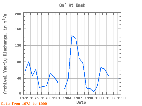
| Year | Jan | Feb | Mar | Apr | May | Jun | Jul | Aug | Sep | Oct | Nov | Dec | Annual | 1969 | 2.40 | 2.10 | 1.74 | 1970 | 4.34 | 2.70 | 56.40 | 21.20 | 28.10 | 46.80 | 26.50 | 1971 | 294.00 | 301.00 | 64.20 | 19.70 | 11.80 | 8.78 | 6.83 | 1972 | 5.16 | 4.54 | 4.09 | 22.80 | 117.00 | 53.10 | 123.00 | 141.00 | 67.70 | 66.00 | 61.10 | 25.10 | 57.55 | 1973 | 13.70 | 8.10 | 7.02 | 56.30 | 223.00 | 311.00 | 221.00 | 58.00 | 20.60 | 15.60 | 12.40 | 8.47 | 79.60 | 1974 | 5.96 | 4.43 | 4.13 | 50.50 | 185.00 | 171.00 | 77.50 | 19.60 | 12.20 | 12.20 | 6.52 | 5.29 | 46.19 | 1975 | 5.22 | 5.36 | 4.86 | 40.60 | 188.00 | 250.00 | 182.00 | 18.00 | 13.60 | 14.40 | 5.14 | 4.16 | 60.95 | 1976 | 3.82 | 3.11 | 3.39 | 12.10 | 92.70 | 47.40 | 15.30 | 10.40 | 13.80 | 5.68 | 2.97 | 3.61 | 17.86 | 1977 | 3.06 | 2.92 | 3.97 | 31.70 | 109.00 | 53.20 | 8.24 | 3.44 | 4.47 | 7.04 | 7.82 | 3.68 | 19.88 | 1978 | 2.83 | 2.36 | 3.27 | 35.10 | 97.40 | 46.80 | 20.50 | 8.91 | 8.72 | 14.40 | 11.60 | 8.44 | 21.69 | 1979 | 6.98 | 3.92 | 2.58 | 7.26 | 111.00 | 219.00 | 129.00 | 56.30 | 27.20 | 24.40 | 31.70 | 13.80 | 52.76 | 1980 | 11.00 | 6.33 | 5.92 | 42.70 | 172.00 | 127.00 | 34.50 | 36.40 | 36.60 | 32.10 | 18.70 | 6.18 | 44.12 | 1981 | 3.79 | 4.06 | 2.65 | 45.30 | 171.00 | 83.60 | 19.70 | 9.39 | 6.85 | 8.54 | 4.60 | 2.77 | 30.19 | 1982 | 1.55 | 1.38 | 1.04 | 16.30 | 30.60 | 4.62 | 0.97 | 0.86 | 4.93 | 4.15 | 3.35 | 1983 | 3.15 | 3.06 | 3.42 | 37.60 | 65.50 | 36.70 | 8.53 | 4.58 | 5.47 | 7.91 | 7.28 | 5.06 | 15.69 | 1984 | 4.29 | 3.69 | 4.22 | 21.30 | 116.00 | 114.00 | 64.30 | 56.70 | 27.70 | 22.30 | 32.90 | 15.80 | 40.27 | 1985 | 5.90 | 6.56 | 5.62 | 35.60 | 251.00 | 306.00 | 338.00 | 284.00 | 211.00 | 148.00 | 87.40 | 47.80 | 143.91 | 1986 | 27.80 | 17.70 | 10.20 | 56.80 | 232.00 | 370.00 | 415.00 | 242.00 | 109.00 | 81.00 | 57.80 | 28.80 | 137.34 | 1987 | 11.10 | 9.76 | 9.57 | 37.10 | 204.00 | 285.00 | 284.00 | 75.70 | 27.70 | 54.40 | 40.70 | 15.50 | 87.88 | 1988 | 9.73 | 9.31 | 10.00 | 63.70 | 232.00 | 307.00 | 224.00 | 32.80 | 16.10 | 13.20 | 9.26 | 5.28 | 77.70 | 1989 | 5.61 | 4.37 | 4.50 | 25.00 | 56.90 | 55.50 | 19.10 | 5.77 | 6.10 | 5.59 | 4.59 | 2.94 | 16.33 | 1990 | 2.75 | 2.23 | 3.94 | 27.80 | 73.70 | 35.50 | 5.52 | 3.40 | 4.15 | 6.00 | 5.27 | 2.94 | 14.43 | 1991 | 3.11 | 2.49 | 2.25 | 15.80 | 30.60 | 4.25 | 0.54 | 1.06 | 4.64 | 9.42 | 5.27 | 4.34 | 6.98 | 1992 | 3.94 | 3.58 | 3.44 | 14.20 | 70.40 | 57.50 | 16.20 | 5.52 | 6.95 | 34.00 | 25.20 | 14.10 | 21.25 | 1993 | 8.48 | 4.21 | 3.62 | 32.50 | 201.00 | 264.00 | 136.00 | 35.80 | 23.20 | 28.70 | 34.00 | 19.90 | 65.95 | 1994 | 9.63 | 6.83 | 4.91 | 52.10 | 222.00 | 228.00 | 104.00 | 41.20 | 29.60 | 19.90 | 19.10 | 14.70 | 62.66 | 1995 | 9.30 | 7.09 | 6.44 | 71.40 | 187.00 | 152.00 | 59.70 | 18.40 | 12.60 | 12.30 | 13.00 | 12.20 | 46.79 | 1996 | 8.04 | 5.76 | 4.83 | 7.71 | 90.60 | 135.00 | 93.90 | 76.50 | 79.60 | 112.00 | 115.00 | 58.00 | 65.58 | 1997 | 17.90 | 11.80 | 10.10 | 84.40 | 260.00 | 303.00 | 131.00 | 28.80 | 21.30 | 24.60 | 20.40 | 14.30 | 77.30 | 1998 | 8.38 | 7.26 | 6.62 | 9.85 | 10.70 | 226.00 | 129.00 | 23.60 | 11.90 | 10.80 | 9.14 | 8.80 | 38.50 | 1999 | 6.74 | 5.83 | 4.92 | 29.20 | 147.00 | 108.00 | 34.20 | 15.70 | 10.30 | 8.23 | 6.69 | 5.43 | 31.85 |
|---|
| Other Close Sites | ||||||
|---|---|---|---|---|---|---|
| PointID | Latitude | Longitude | Drainage Area | Source | Name | |
| 6950 | "Irtish At Omsk" | 55.02 | -1100479 | SHI | 1824.00 | |
 Return to R-Arctic Net Home Page