|
|
| Point ID: 3531 | Downloads | Plots | Site Data | Other Close Sites | Code: 06KC001 |
|
| Download | |
|---|---|
| Site Descriptor Information | Site Time Series Data |
| Link to all available data | |
|
|
|
| View: | Statistics | All |
| Units: | mm |
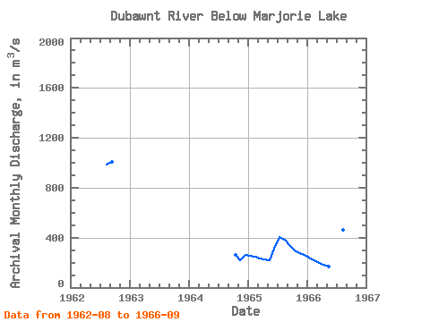
| Year | Jan | Feb | Mar | Apr | May | Jun | Jul | Aug | Sep | Oct | Nov | Dec | Annual | 1962 | 985.00 | 1010.00 | 1964 | 262.00 | 217.00 | 260.00 | 1965 | 252.00 | 244.00 | 234.00 | 225.00 | 218.00 | 310.00 | 405.00 | 381.00 | 339.00 | 299.00 | 275.00 | 260.00 | 286.83 | 1966 | 242.00 | 222.00 | 200.00 | 183.00 | 167.00 | 480.00 | 494.00 | 459.00 | 415.00 |
|---|
| Other Close Sites | ||||||
|---|---|---|---|---|---|---|
| PointID | Latitude | Longitude | Drainage Area | Source | Name | |
| 3532 | "DUBAWNT RIVER AT OUTLET OF MARJORIE LAKE" | 64.26 | 472843 | Hydat | ||
 Return to R-Arctic Net Home Page