|
|
| Point ID: 3133 | Downloads | Plots | Site Data | Code: 06GA001 |
|
| Download | |
|---|---|
| Site Descriptor Information | Site Time Series Data |
| Link to all available data | |
|
|
|
| View: | Statistics | All |
| Units: | mm |
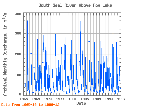
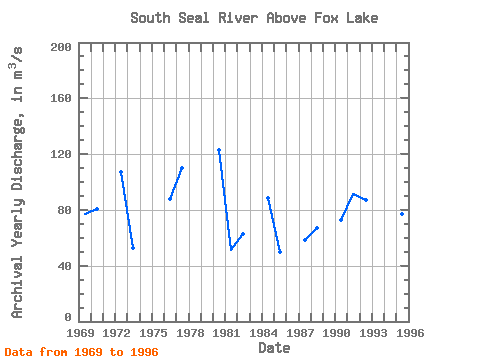
| Year | Jan | Feb | Mar | Apr | May | Jun | Jul | Aug | Sep | Oct | Nov | Dec | Annual | 1965 | 57.80 | 50.30 | 32.50 | 1966 | 24.40 | 177.00 | 360.00 | 175.00 | 88.50 | 50.00 | 27.40 | 25.60 | 24.00 | 1967 | 21.10 | 16.40 | 12.30 | 203.00 | 93.80 | 51.70 | 1968 | 14.30 | 14.90 | 134.00 | 77.80 | 93.40 | 126.00 | 95.60 | 63.90 | 1969 | 38.20 | 23.40 | 21.30 | 21.80 | 30.60 | 67.90 | 69.10 | 61.80 | 270.00 | 173.00 | 98.80 | 49.80 | 77.14 | 1970 | 32.80 | 21.00 | 18.70 | 22.00 | 98.00 | 195.00 | 97.10 | 83.10 | 92.00 | 94.70 | 139.00 | 76.00 | 80.78 | 1971 | 37.20 | 28.10 | 21.30 | 160.00 | 289.00 | 220.00 | 249.00 | 242.00 | 180.00 | 104.00 | 1972 | 53.80 | 31.10 | 24.30 | 23.40 | 205.00 | 234.00 | 193.00 | 129.00 | 127.00 | 115.00 | 88.50 | 62.40 | 107.21 | 1973 | 38.80 | 29.40 | 25.10 | 20.70 | 147.00 | 118.00 | 76.00 | 47.40 | 37.00 | 36.00 | 32.80 | 24.60 | 52.73 | 1974 | 19.60 | 17.00 | 15.00 | 88.50 | 127.00 | 110.00 | 77.50 | 54.40 | 40.70 | 1975 | 31.80 | 21.10 | 15.90 | 25.60 | 294.00 | 233.00 | 149.00 | 112.00 | 79.80 | 49.60 | 1976 | 32.60 | 25.40 | 22.20 | 27.70 | 161.00 | 170.00 | 115.00 | 71.80 | 137.00 | 132.00 | 96.90 | 61.70 | 87.78 | 1977 | 39.60 | 30.00 | 27.50 | 81.60 | 213.00 | 230.00 | 232.00 | 172.00 | 124.00 | 91.30 | 52.70 | 26.10 | 109.98 | 1978 | 18.80 | 18.60 | 18.60 | 18.60 | 129.00 | 216.00 | 279.00 | 205.00 | 108.00 | 53.10 | 1979 | 27.60 | 16.00 | 10.60 | 10.80 | 92.10 | 72.30 | 72.80 | 94.40 | 62.90 | 38.80 | 1980 | 24.60 | 16.70 | 13.00 | 30.50 | 122.00 | 175.00 | 123.00 | 279.00 | 341.00 | 192.00 | 107.00 | 50.80 | 122.88 | 1981 | 28.30 | 25.90 | 24.90 | 24.60 | 125.00 | 146.00 | 72.00 | 36.00 | 37.40 | 38.80 | 35.30 | 19.80 | 51.17 | 1982 | 12.70 | 10.00 | 8.74 | 8.77 | 143.00 | 199.00 | 105.00 | 63.00 | 79.00 | 61.40 | 36.70 | 27.00 | 62.86 | 1983 | 23.00 | 18.60 | 15.00 | 12.70 | 19.50 | 164.00 | 122.00 | 357.00 | 258.00 | 128.00 | 64.30 | 1984 | 45.60 | 33.80 | 23.50 | 78.80 | 216.00 | 186.00 | 110.00 | 85.70 | 121.00 | 79.30 | 51.60 | 34.70 | 88.83 | 1985 | 24.80 | 20.60 | 19.00 | 17.90 | 73.70 | 186.00 | 78.70 | 53.10 | 43.70 | 36.70 | 26.30 | 18.60 | 49.92 | 1986 | 14.30 | 11.90 | 10.60 | 10.00 | 260.00 | 207.00 | 132.00 | 80.30 | 49.60 | 35.70 | 1987 | 29.70 | 25.80 | 22.00 | 18.80 | 86.10 | 161.00 | 105.00 | 57.10 | 61.00 | 53.60 | 45.70 | 31.20 | 58.08 | 1988 | 23.20 | 20.00 | 18.50 | 17.70 | 129.00 | 257.00 | 143.00 | 80.70 | 40.00 | 29.30 | 23.80 | 21.30 | 66.96 | 1989 | 20.70 | 19.30 | 17.70 | 16.20 | 163.00 | 94.90 | 63.30 | 52.70 | 35.50 | 18.50 | 1990 | 15.70 | 16.50 | 16.90 | 17.50 | 45.70 | 260.00 | 195.00 | 101.00 | 63.00 | 62.70 | 50.00 | 33.40 | 73.12 | 1991 | 25.50 | 19.20 | 14.20 | 11.50 | 120.00 | 188.00 | 142.00 | 134.00 | 159.00 | 148.00 | 81.30 | 51.30 | 91.17 | 1992 | 39.50 | 32.60 | 29.50 | 38.50 | 188.00 | 169.00 | 81.50 | 49.80 | 105.00 | 163.00 | 98.00 | 53.10 | 87.29 | 1993 | 36.20 | 29.00 | 24.80 | 24.50 | 134.00 | 86.00 | 92.60 | 104.00 | 111.00 | 104.00 | 65.90 | 41.50 | 71.12 | 1994 | 26.00 | 18.10 | 16.70 | 16.20 | 169.00 | 328.00 | 137.00 | 51.60 | 28.30 | 21.50 | 19.20 | 17.50 | 70.76 | 1995 | 16.00 | 14.50 | 12.60 | 11.00 | 37.50 | 63.00 | 35.30 | 258.00 | 236.00 | 134.00 | 71.30 | 35.40 | 77.05 | 1996 | 21.40 | 18.30 | 17.10 | 21.70 | 68.10 | 118.00 | 140.00 | 73.00 | 54.90 | 46.70 | 35.00 | 21.00 | 52.93 |
|---|
 Return to R-Arctic Net Home Page