|
|
|||||||||||||||||
| Point ID: 7400 | Downloads | Plots | Site Data | Code: 70221 |
|
|
|||||||||||||||||
| Download | |
|---|---|
| Site Descriptor Information | Site Time Series Data |
| Link to all available data | |
|
|
| View: | Statistics | Time Series |
| Units: | mm |
| Statistic | Jan | Feb | Mar | Apr | May | Jun | Jul | Aug | Sep | Oct | Nov | Dec | Annual |
|---|---|---|---|---|---|---|---|---|---|---|---|---|---|
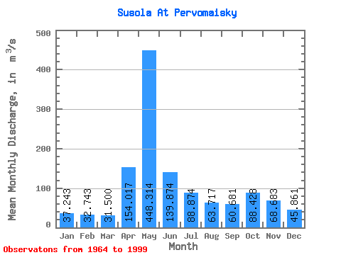
| Mean | 37.24 | 32.74 | 31.50 | 154.02 | 448.31 | 139.87 | 88.87 | 63.72 | 60.68 | 88.43 | 68.68 | 45.86 | 105.04 |
| Standard Deviation | 8.76 | 7.09 | 6.06 | 117.84 | 180.61 | 69.30 | 45.02 | 34.98 | 22.62 | 34.71 | 28.90 | 12.88 | 21.83 |
| Min | 14.40 | 12.70 | 12.80 | 37.60 | 107.00 | 47.80 | 22.60 | 14.50 | 17.70 | 39.90 | 23.10 | 13.10 | 45.72 |
| Max | 62.40 | 54.20 | 43.60 | 465.00 | 864.00 | 288.00 | 218.00 | 200.00 | 122.00 | 166.00 | 172.00 | 78.40 | 146.58 |
| Coefficient of Variation | 0.23 | 0.22 | 0.19 | 0.77 | 0.40 | 0.49 | 0.51 | 0.55 | 0.37 | 0.39 | 0.42 | 0.28 | 0.21 |
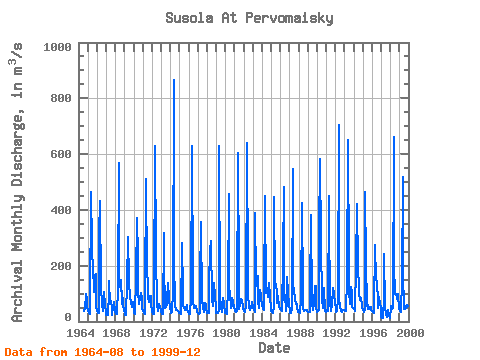
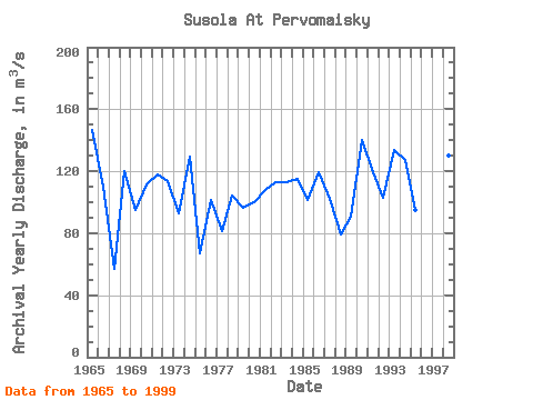
| Year | Jan | Feb | Mar | Apr | May | Jun | Jul | Aug | Sep | Oct | Nov | Dec | Annual | 1964 | 36.80 | 44.90 | 99.10 | 75.60 | 51.10 | 1965 | 37.80 | 29.50 | 28.20 | 58.00 | 464.00 | 271.00 | 173.00 | 200.00 | 107.00 | 166.00 | 172.00 | 52.50 | 146.58 | 1966 | 41.10 | 30.90 | 29.40 | 315.00 | 433.00 | 121.00 | 64.00 | 35.90 | 53.50 | 104.00 | 59.30 | 29.20 | 109.69 | 1967 | 22.30 | 23.50 | 23.50 | 103.00 | 145.00 | 63.40 | 73.80 | 44.90 | 24.10 | 51.40 | 71.10 | 35.00 | 56.75 | 1968 | 29.00 | 26.60 | 26.40 | 125.00 | 568.00 | 123.00 | 124.00 | 147.00 | 63.60 | 110.00 | 63.80 | 36.70 | 120.26 | 1969 | 34.10 | 24.90 | 23.60 | 137.00 | 303.00 | 147.00 | 132.00 | 95.10 | 61.10 | 63.10 | 53.40 | 68.90 | 95.27 | 1970 | 29.70 | 28.00 | 27.80 | 158.00 | 372.00 | 229.00 | 111.00 | 63.80 | 83.60 | 102.00 | 84.20 | 46.50 | 111.30 | 1971 | 40.20 | 31.50 | 28.50 | 91.00 | 510.00 | 165.00 | 149.00 | 89.30 | 68.90 | 91.10 | 91.60 | 62.50 | 118.22 | 1972 | 39.30 | 28.50 | 28.50 | 103.00 | 629.00 | 241.00 | 58.50 | 37.00 | 41.00 | 62.10 | 49.30 | 42.30 | 113.29 | 1973 | 32.90 | 25.70 | 28.00 | 317.00 | 207.00 | 47.80 | 52.20 | 63.30 | 77.40 | 139.00 | 79.70 | 47.40 | 93.12 | 1974 | 38.40 | 32.10 | 32.80 | 107.00 | 864.00 | 228.00 | 60.80 | 40.60 | 41.00 | 39.90 | 38.90 | 32.20 | 129.64 | 1975 | 30.80 | 30.80 | 27.50 | 281.00 | 107.00 | 57.20 | 50.70 | 40.50 | 46.90 | 58.10 | 42.80 | 33.50 | 67.23 | 1976 | 28.20 | 26.80 | 28.00 | 83.40 | 630.00 | 130.00 | 68.40 | 47.90 | 55.60 | 54.20 | 33.80 | 33.70 | 101.67 | 1977 | 31.30 | 28.30 | 30.00 | 142.00 | 357.00 | 64.80 | 65.40 | 46.60 | 35.00 | 67.10 | 62.80 | 49.00 | 81.61 | 1978 | 31.70 | 30.20 | 30.70 | 133.00 | 258.00 | 288.00 | 75.30 | 56.10 | 68.80 | 139.00 | 91.40 | 48.90 | 104.26 | 1979 | 31.80 | 29.40 | 29.50 | 38.40 | 629.00 | 88.50 | 53.60 | 35.20 | 41.00 | 84.70 | 63.60 | 31.80 | 96.38 | 1980 | 30.10 | 31.30 | 27.00 | 123.00 | 458.00 | 125.00 | 97.70 | 48.00 | 59.80 | 84.30 | 68.70 | 47.90 | 100.07 | 1981 | 41.60 | 36.40 | 33.20 | 37.60 | 605.00 | 151.00 | 45.80 | 63.80 | 81.60 | 77.20 | 78.40 | 46.90 | 108.21 | 1982 | 37.10 | 34.80 | 33.90 | 60.40 | 638.00 | 170.00 | 99.20 | 53.10 | 41.80 | 51.40 | 63.50 | 70.00 | 112.77 | 1983 | 49.60 | 41.90 | 35.30 | 389.00 | 145.00 | 129.00 | 164.00 | 69.10 | 48.60 | 113.00 | 93.40 | 78.40 | 113.03 | 1984 | 62.40 | 44.80 | 39.60 | 103.00 | 450.00 | 103.00 | 114.00 | 89.10 | 104.00 | 139.00 | 87.80 | 43.70 | 115.03 | 1985 | 39.10 | 35.60 | 30.40 | 50.60 | 448.00 | 132.00 | 133.00 | 96.80 | 65.80 | 89.90 | 50.80 | 45.00 | 101.42 | 1986 | 46.30 | 41.10 | 36.10 | 224.00 | 483.00 | 77.10 | 93.20 | 38.60 | 71.60 | 158.00 | 102.00 | 61.70 | 119.39 | 1987 | 35.30 | 30.50 | 29.20 | 46.30 | 547.00 | 130.00 | 114.00 | 82.00 | 64.00 | 63.10 | 52.50 | 35.80 | 102.47 | 1988 | 34.00 | 30.70 | 30.80 | 83.50 | 425.00 | 103.00 | 45.60 | 37.50 | 40.00 | 42.60 | 40.20 | 38.10 | 79.25 | 1989 | 32.80 | 32.40 | 32.90 | 93.80 | 383.00 | 61.70 | 44.40 | 40.60 | 68.10 | 126.00 | 128.00 | 46.80 | 90.88 | 1990 | 33.30 | 38.10 | 42.70 | 314.00 | 584.00 | 283.00 | 78.30 | 47.40 | 69.30 | 120.00 | 36.20 | 34.60 | 140.07 | 1991 | 42.30 | 38.80 | 36.90 | 449.00 | 369.00 | 70.10 | 37.40 | 58.20 | 54.90 | 120.00 | 96.80 | 62.60 | 119.67 | 1992 | 49.70 | 34.80 | 35.90 | 80.50 | 703.00 | 79.00 | 53.60 | 36.10 | 35.50 | 41.10 | 41.50 | 41.70 | 102.70 | 1993 | 36.70 | 36.90 | 37.10 | 154.00 | 651.00 | 188.00 | 106.00 | 64.30 | 122.00 | 107.00 | 50.20 | 47.60 | 133.40 | 1994 | 46.70 | 37.50 | 35.90 | 203.00 | 422.00 | 196.00 | 218.00 | 98.40 | 78.00 | 83.20 | 59.20 | 48.00 | 127.16 | 1995 | 42.30 | 34.10 | 43.30 | 465.00 | 209.00 | 61.30 | 45.20 | 57.40 | 45.40 | 45.70 | 53.00 | 40.20 | 95.16 | 1996 | 39.30 | 34.70 | 30.60 | 43.20 | 274.00 | 149.00 | 142.00 | 70.30 | 48.20 | 88.80 | 60.30 | 56.90 | 86.44 | 1997 | 14.40 | 12.70 | 12.80 | 83.10 | 241.00 | 51.70 | 22.60 | 14.50 | 17.70 | 41.90 | 23.10 | 13.10 | 45.72 | 1998 | 49.20 | 54.20 | 43.60 | 46.80 | 663.00 | 198.00 | 99.70 | 99.90 | 83.90 | 82.10 | 97.80 | 45.10 | 130.28 | 1999 | 42.70 | 38.00 | 32.90 | 149.00 | 517.00 | 173.00 | 45.20 | 48.70 | 70.90 | 78.30 | 55.90 | 45.70 | 108.11 |
|---|
 Return to R-Arctic Net Home Page