|
|
|||||||||||||||||
| Point ID: 7506 | Downloads | Plots | Site Data | Code: 70499 |
|
|
|||||||||||||||||
| Download | |
|---|---|
| Site Descriptor Information | Site Time Series Data |
| Link to all available data | |
|
|
| View: | Statistics | Time Series |
| Units: | m3/s |
| Statistic | Jan | Feb | Mar | Apr | May | Jun | Jul | Aug | Sep | Oct | Nov | Dec | Annual |
|---|---|---|---|---|---|---|---|---|---|---|---|---|---|
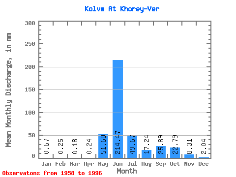
| Mean | 0.67 | 0.26 | 0.18 | 0.23 | 51.68 | 214.47 | 49.66 | 17.24 | 25.89 | 22.79 | 8.31 | 2.04 | 408.37 |
| Standard Deviation | 0.55 | 0.21 | 0.16 | 0.21 | 70.74 | 86.30 | 34.81 | 14.02 | 14.71 | 13.70 | 8.70 | 1.23 | 87.27 |
| Min | 0.06 | 0.01 | 0.00 | 0.01 | 0.08 | 85.29 | 14.64 | 3.98 | 2.98 | 2.16 | 0.73 | 0.10 | 241.20 |
| Max | 2.06 | 0.82 | 0.60 | 0.75 | 221.78 | 450.64 | 198.28 | 73.44 | 60.65 | 63.65 | 41.13 | 4.95 | 614.90 |
| Coefficient of Variation | 0.82 | 0.80 | 0.88 | 0.91 | 1.37 | 0.40 | 0.70 | 0.81 | 0.57 | 0.60 | 1.05 | 0.60 | 0.21 |
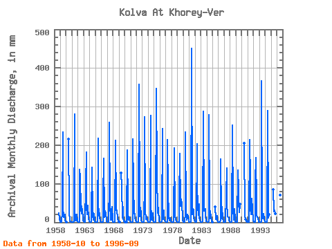
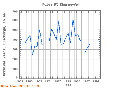
| Year | Jan | Feb | Mar | Apr | May | Jun | Jul | Aug | Sep | Oct | Nov | Dec | Annual | 1958 | 25.51 | 9.29 | 1.11 | 1959 | 0.21 | 0.15 | 0.16 | 0.11 | 27.71 | 234.09 | 39.75 | 13.86 | 20.23 | 20.46 | 5.31 | 1.59 | 365.59 | 1960 | 0.36 | 0.13 | 216.55 | 28.25 | 5.04 | 2.98 | 2.16 | 0.73 | 0.20 | 1961 | 0.11 | 0.08 | 0.09 | 0.07 | 2.25 | 280.52 | 37.80 | 5.09 | 4.43 | 20.51 | 16.68 | 2.14 | 372.97 | 1962 | 0.48 | 0.21 | 0.14 | 0.69 | 141.98 | 116.09 | 35.94 | 23.11 | 42.60 | 30.94 | 11.04 | 4.86 | 406.34 | 1963 | 2.06 | 0.72 | 0.24 | 0.18 | 98.89 | 181.01 | 40.34 | 21.49 | 42.31 | 45.38 | 9.24 | 2.43 | 444.01 | 1964 | 0.42 | 0.10 | 0.07 | 0.03 | 15.08 | 143.10 | 20.22 | 6.80 | 24.02 | 22.08 | 6.40 | 1.50 | 241.20 | 1965 | 0.45 | 0.13 | 0.04 | 0.05 | 0.08 | 217.03 | 54.83 | 16.79 | 24.88 | 15.32 | 3.53 | 1.25 | 336.41 | 1966 | 0.53 | 0.12 | 0.08 | 0.08 | 66.58 | 166.32 | 16.20 | 14.05 | 29.95 | 24.92 | 5.02 | 2.04 | 326.64 | 1967 | 0.36 | 0.12 | 0.13 | 0.28 | 100.36 | 259.20 | 51.41 | 5.88 | 6.16 | 30.40 | 41.13 | 4.95 | 501.41 | 1968 | 0.90 | 0.17 | 0.05 | 0.02 | 10.87 | 212.76 | 47.59 | 32.85 | 30.90 | 12.39 | 2.07 | 0.10 | 352.39 | 1969 | 0.09 | 0.19 | 0.00 | 127.94 | 97.92 | 12.83 | 41.08 | 12.44 | 2.30 | 1.11 | 1970 | 0.06 | 0.01 | 1.42 | 186.70 | 38.97 | 7.25 | 15.69 | 13.81 | 5.92 | 2.07 | 1971 | 0.54 | 0.17 | 0.01 | 0.01 | 0.31 | 215.13 | 94.98 | 23.65 | 34.31 | 11.51 | 5.26 | 2.25 | 389.49 | 1972 | 0.60 | 0.17 | 0.04 | 0.02 | 0.08 | 357.76 | 62.67 | 15.03 | 38.52 | 21.49 | 4.23 | 0.83 | 505.53 | 1973 | 0.32 | 0.12 | 0.11 | 0.11 | 109.18 | 272.94 | 32.80 | 7.88 | 17.15 | 14.98 | 4.69 | 1.50 | 463.13 | 1974 | 0.58 | 0.15 | 0.14 | 0.11 | 0.17 | 277.21 | 54.34 | 6.27 | 25.07 | 25.26 | 4.51 | 1.30 | 398.04 | 1975 | 0.67 | 0.23 | 0.17 | 0.27 | 1.67 | 347.34 | 129.74 | 24.92 | 47.05 | 30.60 | 6.21 | 2.10 | 593.45 | 1976 | 0.92 | 0.55 | 0.37 | 0.22 | 2.04 | 243.56 | 41.27 | 8.32 | 31.98 | 10.77 | 4.17 | 2.33 | 349.46 | 1977 | 1.67 | 0.32 | 0.20 | 0.54 | 221.78 | 87.66 | 14.64 | 3.98 | 12.18 | 12.39 | 3.61 | 3.01 | 358.91 | 1978 | 1.21 | 0.60 | 0.52 | 0.39 | 0.39 | 184.33 | 198.28 | 17.23 | 5.50 | 6.37 | 2.92 | 1.07 | 417.65 | 1979 | 0.27 | 0.21 | 0.15 | 0.19 | 62.18 | 179.12 | 44.06 | 54.83 | 60.65 | 48.32 | 10.95 | 4.41 | 465.20 | 1980 | 1.33 | 0.34 | 0.26 | 0.29 | 25.41 | 233.14 | 33.24 | 7.15 | 21.32 | 21.25 | 15.97 | 2.58 | 364.64 | 1981 | 1.70 | 0.44 | 0.45 | 0.37 | 0.84 | 450.64 | 48.81 | 21.79 | 34.21 | 34.47 | 11.99 | 3.87 | 614.90 | 1982 | 0.53 | 0.28 | 0.17 | 0.75 | 209.54 | 99.04 | 40.88 | 19.83 | 46.67 | 13.37 | 4.79 | 2.84 | 435.77 | 1983 | 1.55 | 0.60 | 0.48 | 0.59 | 2.29 | 287.16 | 40.10 | 30.45 | 34.35 | 35.30 | 18.77 | 2.69 | 457.35 | 1984 | 1.92 | 0.82 | 0.60 | 0.55 | 2.24 | 279.10 | 44.60 | 9.74 | 29.76 | 13.76 | 2.62 | 1.72 | 390.75 | 1985 | 41.08 | 7.49 | 8.72 | 16.70 | 4.88 | 0.86 | 1986 | 0.23 | 0.13 | 0.07 | 0.10 | 6.27 | 163.48 | 26.24 | 10.13 | 40.18 | 7.69 | 3.61 | 1.48 | 261.72 | 1987 | 0.11 | 0.05 | 0.04 | 0.02 | 71.48 | 140.74 | 52.38 | 15.28 | 13.13 | 11.55 | 6.54 | 1.78 | 312.72 | 1988 | 0.47 | 0.05 | 0.05 | 0.05 | 0.63 | 252.09 | 34.66 | 7.54 | 5.54 | 36.96 | 7.49 | 1.62 | 349.58 | 1989 | 0.49 | 0.26 | 0.19 | 0.09 | 140.51 | 87.66 | 53.85 | 27.66 | 45.44 | 48.96 | 1990 | 204.71 | 18.41 | 6.17 | 8.20 | 2.50 | 0.54 | 1991 | 0.10 | 0.04 | 0.05 | 0.27 | 220.80 | 109.46 | 37.16 | 21.54 | 44.54 | 63.65 | 35.82 | 4.05 | 534.05 | 1992 | 0.35 | 0.16 | 0.11 | 0.13 | 108.69 | 167.75 | 56.30 | 16.99 | 14.07 | 12.68 | 1.74 | 0.84 | 378.99 | 1993 | 0.51 | 0.41 | 0.44 | 0.49 | 1.11 | 365.82 | 23.25 | 9.45 | 13.69 | 23.21 | 8.91 | 2.53 | 454.48 | 1994 | 0.78 | 0.49 | 0.30 | 0.20 | 0.81 | 288.58 | 23.79 | 11.36 | 21.09 | 1995 | 85.29 | 28.69 | 31.87 | 21.89 | 1996 | 101.83 | 73.44 | 23.31 |
|---|
 Return to R-Arctic Net Home Page