|
|
|||||||||||||||||
| Point ID: 5605 | Downloads | Plots | Site Data | Other Close Sites | Code: 06EA010 |
|
|
|||||||||||||||||
| Download | |
|---|---|
| Site Descriptor Information | Site Time Series Data |
| Link to all available data | |
|
|
| View: | Statistics | Time Series |
| Units: | m3/s |
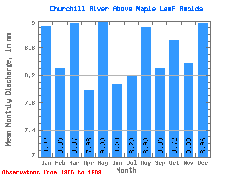
| Statistic | Jan | Feb | Mar | Apr | May | Jun | Jul | Aug | Sep | Oct | Nov | Dec | Annual |
|---|---|---|---|---|---|---|---|---|---|---|---|---|---|
| Mean | 8.66 | 8.14 | 8.72 | 7.76 | 8.75 | 7.85 | 7.96 | 8.65 | 8.07 | 8.47 | 8.15 | 8.71 | 99.34 |
| Standard Deviation | 0.98 | 0.59 | 0.65 | 1.31 | 0.55 | 0.94 | 1.57 | 0.32 | 0.53 | 0.58 | 0.78 | 0.94 | 7.21 |
| Min | 7.54 | 7.46 | 7.98 | 6.60 | 8.24 | 6.90 | 6.18 | 8.29 | 7.54 | 7.67 | 7.17 | 7.37 | 94.18 |
| Max | 9.34 | 8.56 | 9.21 | 9.18 | 9.32 | 8.78 | 9.15 | 9.01 | 8.56 | 8.97 | 8.83 | 9.41 | 107.58 |
| Coefficient of Variation | 0.11 | 0.07 | 0.07 | 0.17 | 0.06 | 0.12 | 0.20 | 0.04 | 0.07 | 0.07 | 0.10 | 0.11 | 0.07 |
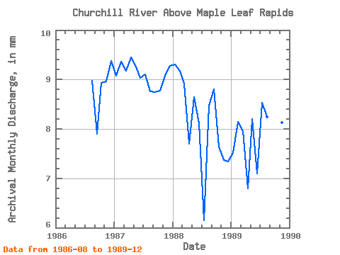
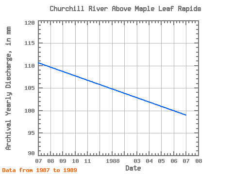
| Year | Jan | Feb | Mar | Apr | May | Jun | Jul | Aug | Sep | Oct | Nov | Dec | Annual | 1986 | 9.01 | 7.68 | 8.97 | 8.71 | 9.41 | 1987 | 9.11 | 8.56 | 9.21 | 9.18 | 9.32 | 8.78 | 9.15 | 8.79 | 8.50 | 8.80 | 8.83 | 9.31 | 107.58 | 1988 | 9.34 | 8.39 | 8.96 | 7.48 | 8.68 | 7.89 | 6.18 | 8.51 | 8.56 | 7.67 | 7.17 | 7.37 | 96.27 | 1989 | 7.54 | 7.46 | 7.98 | 6.60 | 8.24 | 6.90 | 8.56 | 8.29 | 7.54 | 8.45 | 7.90 | 8.75 | 94.18 |
|---|
| Other Close Sites | ||||||
|---|---|---|---|---|---|---|
| PointID | Latitude | Longitude | Drainage Area | Source | Name | |
| 5603 | "CHURCHILL RIVER AT SANDY BAY" | 55.52 | 805163 | Hydat | ||
 Return to R-Arctic Net Home Page