|
|
|||||||||||||||||
| Point ID: 8264 | Downloads | Plots | Site Data | Code: 8374 |
|
|
|||||||||||||||||
| Download | |
|---|---|
| Site Descriptor Information | Site Time Series Data |
| Link to all available data | |
|
|
| View: | Statistics | Time Series |
| Units: | mm |
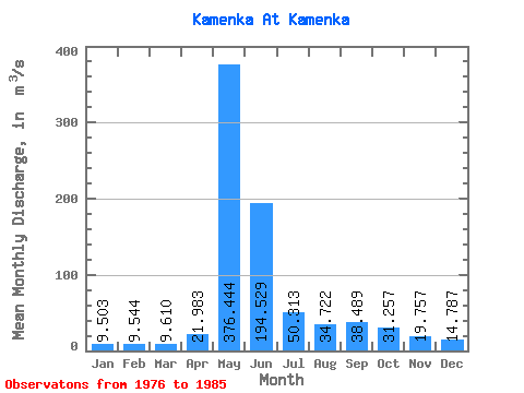
| Statistic | Jan | Feb | Mar | Apr | May | Jun | Jul | Aug | Sep | Oct | Nov | Dec | Annual |
|---|---|---|---|---|---|---|---|---|---|---|---|---|---|
| Mean | 9.50 | 9.54 | 9.61 | 21.98 | 376.44 | 194.53 | 50.31 | 34.72 | 38.49 | 31.26 | 19.76 | 14.79 | 74.25 |
| Standard Deviation | 3.87 | 2.04 | 3.44 | 27.23 | 78.70 | 98.75 | 17.12 | 9.98 | 11.62 | 6.72 | 5.45 | 4.73 | 4.87 |
| Min | 3.75 | 4.76 | 2.69 | 7.36 | 258.00 | 65.70 | 32.90 | 20.40 | 17.80 | 21.90 | 11.70 | 7.72 | 68.65 |
| Max | 16.60 | 11.70 | 13.50 | 89.00 | 479.00 | 385.00 | 84.50 | 54.20 | 54.80 | 44.00 | 28.30 | 22.00 | 79.58 |
| Coefficient of Variation | 0.41 | 0.21 | 0.36 | 1.24 | 0.21 | 0.51 | 0.34 | 0.29 | 0.30 | 0.21 | 0.28 | 0.32 | 0.07 |
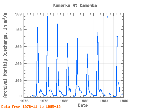
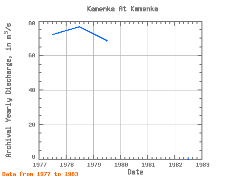
| Year | Jan | Feb | Mar | Apr | May | Jun | Jul | Aug | Sep | Oct | Nov | Dec | Annual | 1976 | 11.70 | 1977 | 8.69 | 8.15 | 6.46 | 12.60 | 414.00 | 230.00 | 37.40 | 27.60 | 47.70 | 31.30 | 23.60 | 16.70 | 72.02 | 1978 | 10.80 | 10.00 | 13.50 | 13.50 | 479.00 | 205.00 | 32.90 | 43.50 | 43.80 | 33.90 | 22.00 | 13.30 | 76.77 | 1979 | 7.65 | 10.10 | 11.70 | 12.00 | 434.00 | 175.00 | 44.60 | 31.00 | 34.80 | 29.50 | 17.60 | 15.90 | 68.65 | 1980 | 10.60 | 9.49 | 9.73 | 13.20 | 318.00 | 153.00 | 39.10 | 54.20 | 36.40 | 1981 | 6.33 | 10.20 | 10.40 | 89.00 | 351.00 | 65.70 | 66.10 | 37.70 | 38.80 | 29.90 | 1982 | 10.50 | 11.00 | 17.70 | 258.00 | 148.00 | 47.90 | 27.00 | 25.10 | 21.90 | 15.80 | 13.10 | 1983 | 11.60 | 11.00 | 11.40 | 10.50 | 299.00 | 385.00 | 50.00 | 34.90 | 47.20 | 44.00 | 28.30 | 22.00 | 79.58 | 1984 | 16.60 | 11.70 | 476.00 | 20.40 | 17.80 | 1985 | 3.75 | 4.76 | 2.69 | 7.36 | 359.00 | 84.50 | 36.20 | 54.80 | 28.30 | 19.30 | 7.72 |
|---|
 Return to R-Arctic Net Home Page