|
|
|||||||||||||||||
| Point ID: 6874 | Downloads | Plots | Site Data | Code: 10500 |
|
|
|||||||||||||||||
| Download | |
|---|---|
| Site Descriptor Information | Site Time Series Data |
| Link to all available data | |
|
|
| View: | Statistics | Time Series |
| Units: | mm |
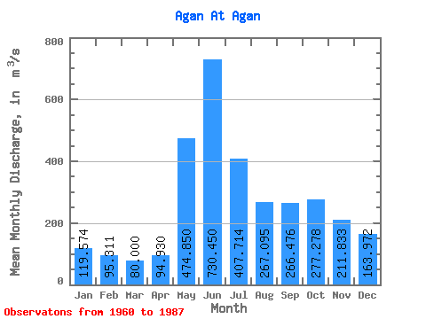
| Statistic | Jan | Feb | Mar | Apr | May | Jun | Jul | Aug | Sep | Oct | Nov | Dec | Annual |
|---|---|---|---|---|---|---|---|---|---|---|---|---|---|
| Mean | 119.57 | 95.31 | 80.00 | 94.93 | 474.85 | 730.45 | 407.71 | 267.10 | 266.48 | 277.28 | 211.83 | 163.97 | 274.65 |
| Standard Deviation | 46.14 | 28.36 | 15.72 | 26.20 | 181.36 | 217.67 | 170.79 | 115.04 | 123.16 | 134.65 | 97.92 | 78.06 | 61.35 |
| Min | 66.50 | 52.40 | 49.40 | 48.50 | 125.00 | 336.00 | 222.00 | 142.00 | 141.00 | 137.00 | 108.00 | 86.30 | 193.97 |
| Max | 272.00 | 163.00 | 111.00 | 166.00 | 822.00 | 1060.00 | 785.00 | 517.00 | 588.00 | 598.00 | 526.00 | 433.00 | 389.89 |
| Coefficient of Variation | 0.39 | 0.30 | 0.20 | 0.28 | 0.38 | 0.30 | 0.42 | 0.43 | 0.46 | 0.49 | 0.46 | 0.48 | 0.22 |
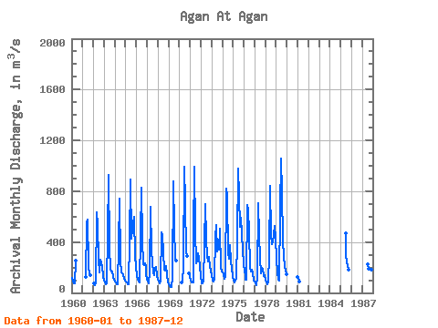
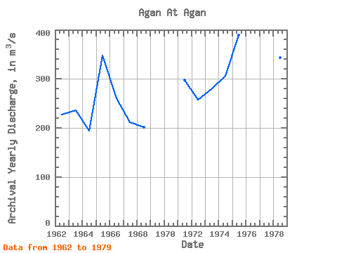
| Year | Jan | Feb | Mar | Apr | May | Jun | Jul | Aug | Sep | Oct | Nov | Dec | Annual | 1960 | 119.00 | 92.00 | 77.80 | 76.30 | 253.00 | 1961 | 124.00 | 550.00 | 574.00 | 222.00 | 142.00 | 141.00 | 1962 | 75.30 | 63.60 | 63.60 | 85.90 | 633.00 | 538.00 | 262.00 | 160.00 | 262.00 | 243.00 | 203.00 | 133.00 | 226.87 | 1963 | 98.50 | 81.20 | 67.70 | 76.30 | 459.00 | 927.00 | 361.00 | 183.00 | 165.00 | 169.00 | 129.00 | 105.00 | 235.14 | 1964 | 89.80 | 81.80 | 70.50 | 67.80 | 367.00 | 741.00 | 255.00 | 160.00 | 154.00 | 137.00 | 108.00 | 95.80 | 193.97 | 1965 | 89.30 | 83.60 | 70.40 | 69.70 | 411.00 | 889.00 | 428.00 | 496.00 | 541.00 | 598.00 | 288.00 | 202.00 | 347.17 | 1966 | 139.00 | 106.00 | 89.60 | 83.80 | 445.00 | 829.00 | 409.00 | 224.00 | 219.00 | 233.00 | 204.00 | 144.00 | 260.45 | 1967 | 110.00 | 90.80 | 78.60 | 166.00 | 675.00 | 336.00 | 242.00 | 159.00 | 142.00 | 198.00 | 207.00 | 137.00 | 211.78 | 1968 | 107.00 | 91.80 | 77.30 | 97.30 | 480.00 | 453.00 | 322.00 | 181.00 | 177.00 | 214.00 | 137.00 | 86.30 | 201.97 | 1969 | 66.50 | 52.40 | 49.40 | 48.50 | 125.00 | 878.00 | 514.00 | 269.00 | 253.00 | 1970 | 80.70 | 82.70 | 220.00 | 991.00 | 708.00 | 316.00 | 292.00 | 155.00 | 129.00 | 1971 | 93.30 | 81.80 | 79.80 | 79.00 | 472.00 | 994.00 | 498.00 | 235.00 | 255.00 | 309.00 | 276.00 | 203.00 | 297.99 | 1972 | 141.00 | 74.50 | 73.10 | 92.10 | 384.00 | 702.00 | 428.00 | 287.00 | 250.00 | 281.00 | 202.00 | 173.00 | 257.31 | 1973 | 138.00 | 97.80 | 87.50 | 110.00 | 438.00 | 532.00 | 323.00 | 417.00 | 337.00 | 507.00 | 198.00 | 170.00 | 279.61 | 1974 | 161.00 | 147.00 | 111.00 | 126.00 | 822.00 | 761.00 | 315.00 | 272.00 | 373.00 | 255.00 | 187.00 | 136.00 | 305.50 | 1975 | 96.80 | 82.40 | 97.50 | 111.00 | 414.00 | 981.00 | 764.00 | 517.00 | 588.00 | 459.00 | 339.00 | 229.00 | 389.89 | 1976 | 167.00 | 140.00 | 104.00 | 106.00 | 695.00 | 654.00 | 479.00 | 204.00 | 172.00 | 186.00 | 158.00 | 98.40 | 263.62 | 1977 | 87.50 | 73.60 | 60.60 | 118.00 | 708.00 | 457.00 | 266.00 | 156.00 | 197.00 | 188.00 | 136.00 | 141.00 | 215.72 | 1978 | 98.90 | 91.60 | 69.00 | 81.20 | 294.00 | 842.00 | 455.00 | 380.00 | 398.00 | 455.00 | 526.00 | 433.00 | 343.64 | 1979 | 272.00 | 163.00 | 103.00 | 97.00 | 652.00 | 1060.00 | 785.00 | 413.00 | 290.00 | 204.00 | 179.00 | 148.00 | 363.83 | 1981 | 122.00 | 116.00 | 88.90 | 1985 | 470.00 | 299.00 | 250.00 | 215.00 | 182.00 | 1987 | 227.00 | 188.00 | 175.00 | 173.00 | 181.00 | 188.00 |
|---|
 Return to R-Arctic Net Home Page