Kormanka at Ustie
North European Russia
| PointID: | 7326 |
Code: | 49136 |
Latitude (decimal degrees): | 66.03 |
Longitude (decimal degrees): | 30.67 |
Drainage Area (km2): | 168.00 |
Source: | SHI |
Hydrological Zone: | North European Russia |
Name: | Kormanka at Ustie |
Field Definitions
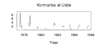
Site Time Series Plot:
Site Data File:
(Units: m3/s)
| ID | Year | Jan | Feb | Mar | Apr | May | Jun | Jul | Aug | Sep | Oct | Nov | Dec |
|---|
| 7326 | 1977 | | | | | | 1.68 | 9.28 | 1.76 | 1.11 | 2.41 | | |
| 7326 | 1978 | | | | | | | 3.75 | 1.98 | 7.60 | 3.00 | | |
| 7326 | 1979 | | | | | | | 1.77 | 0.82 | 1.64 | | | |
| 7326 | 1980 | | | | | | | 0.64 | 0.69 | 0.62 | | | |
| 7326 | 1981 | | | | | | | 2.23 | 3.78 | 2.70 | 2.88 | | |
| 7326 | 1982 | | | | | | | 1.57 | 1.90 | 2.15 | 1.54 | | |
| 7326 | 1983 | | | | | | 2.96 | 0.61 | 0.42 | 0.49 | | | |
| 7326 | 1984 | | | | | | 0.87 | 1.74 | 2.69 | 2.53 | | | |
| 7326 | 1985 | | | | | | | 0.87 | 1.33 | 2.65 | | | |
 Return to R-Arctic Net Home Page