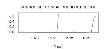
| PointID: | 651 | Code: | 07BB010 | Latitude (decimal degrees): | 54.04 | Longitude (decimal degrees): | -115.04 | Drainage Area (km2): | 64.50 | Source: | Hydat | Hydrological Zone: | Mackenzie | Name: | CONNOR CREEK NEAR ROCHFORT BRIDGE |
|---|
| Download | |
|---|---|
| Site Descriptor Information | Site Time Series Data |
| Link to all available data | |
| ID | Year | Jan | Feb | Mar | Apr | May | Jun | Jul | Aug | Sep | Oct | Nov | Dec |
|---|---|---|---|---|---|---|---|---|---|---|---|---|---|
| 651 | 1975 | 0.00 | 0.00 | ||||||||||
| 651 | 1976 | 0.00 | |||||||||||
| 651 | 1977 | 0.00 | 0.00 | 0.71 | |||||||||
| 651 | 1978 | 0.00 | 0.00 | ||||||||||
| 651 | 1979 | 0.00 | 0.00 | 0.34 | 0.59 | 0.53 |
 Return to R-Arctic Net Home Page