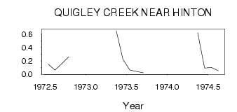
| PointID: | 617 | Code: | 07AF008 | Latitude (decimal degrees): | 53.35 | Longitude (decimal degrees): | -117.40 | Drainage Area (km2): | 15.30 | Source: | Hydat | Hydrological Zone: | Mackenzie | Name: | QUIGLEY CREEK NEAR HINTON |
|---|
| Download | |
|---|---|
| Site Descriptor Information | Site Time Series Data |
| Link to all available data | |
| ID | Year | Jan | Feb | Mar | Apr | May | Jun | Jul | Aug | Sep | Oct | Nov | Dec |
|---|---|---|---|---|---|---|---|---|---|---|---|---|---|
| 617 | 1972 | 0.15 | 0.06 | 0.16 | 0.26 | ||||||||
| 617 | 1973 | 0.65 | 0.22 | 0.06 | 0.04 | 0.02 | |||||||
| 617 | 1974 | 0.62 | 0.09 | 0.10 | 0.05 |
 Return to R-Arctic Net Home Page