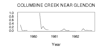
| PointID: | 570 | Code: | 06AA901 | Latitude (decimal degrees): | 54.35 | Longitude (decimal degrees): | -111.14 | Drainage Area (km2): | 241.00 | Source: | Hydat | Hydrological Zone: | Northwest Hudson Bay | Name: | COLUMBINE CREEK NEAR GLENDON |
|---|
| Download | |
|---|---|
| Site Descriptor Information | Site Time Series Data |
| Link to all available data | |
| ID | Year | Jan | Feb | Mar | Apr | May | Jun | Jul | Aug | Sep | Oct | Nov | Dec |
|---|---|---|---|---|---|---|---|---|---|---|---|---|---|
| 570 | 1979 | 0.32 | 3.0e-03 | 3.0e-03 | 7.0e-03 | 0.01 | |||||||
| 570 | 1980 | 1.00 | 0.10 | 0.24 | 0.10 | 0.05 | 0.05 | ||||||
| 570 | 1981 | 0.00 | 0.02 | 0.10 | 0.01 | 1.0e-03 | 6.0e-03 | ||||||
| 570 | 1982 | 0.00 | 0.11 | 7.0e-03 | 0.02 | 5.0e-03 | 4.0e-03 | 2.0e-03 |
 Return to R-Arctic Net Home Page