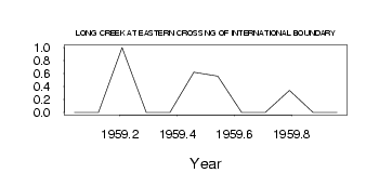
| PointID: | 5529 | Code: | 05NB013 | Latitude (decimal degrees): | 49.01 | Longitude (decimal degrees): | -103.06 | Drainage Area (km2): | 1450.00 | Source: | Hydat | Hydrological Zone: | Nelson | Name: | LONG CREEK AT EASTERN CROSSING OF INTERNATIONAL BOUNDARY |
|---|
| Download | |
|---|---|
| Site Descriptor Information | Site Time Series Data |
| Link to all available data | |
| ID | Year | Jan | Feb | Mar | Apr | May | Jun | Jul | Aug | Sep | Oct | Nov | Dec |
|---|---|---|---|---|---|---|---|---|---|---|---|---|---|
| 5529 | 1959 | 0.00 | 0.00 | 1.00 | 0.00 | 0.00 | 0.62 | 0.56 | 0.00 | 0.00 | 0.34 | 0.00 | 0.00 |
 Return to R-Arctic Net Home Page