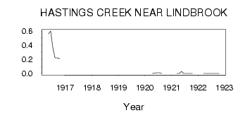
| PointID: | 496 | Code: | 05EB001 | Latitude (decimal degrees): | 53.40 | Longitude (decimal degrees): | -112.82 | Drainage Area (km2): | 295.00 | Source: | Hydat | Hydrological Zone: | Nelson | Name: | HASTINGS CREEK NEAR LINDBROOK |
|---|
| Download | |
|---|---|
| Site Descriptor Information | Site Time Series Data |
| Link to all available data | |
| ID | Year | Jan | Feb | Mar | Apr | May | Jun | Jul | Aug | Sep | Oct | Nov | Dec |
|---|---|---|---|---|---|---|---|---|---|---|---|---|---|
| 496 | 1916 | 0.56 | 0.60 | 0.36 | 0.22 | 0.22 | 0.21 | ||||||
| 496 | 1920 | 0.00 | 5.0e-03 | 0.01 | 0.01 | 0.00 | |||||||
| 496 | 1921 | 0.00 | 0.00 | 0.03 | 0.00 | 0.00 | 0.00 | 0.00 | 0.00 | ||||
| 496 | 1922 | 0.00 | 0.00 | 0.00 | 0.00 | 0.00 | 0.00 | 0.00 | 0.00 |
 Return to R-Arctic Net Home Page