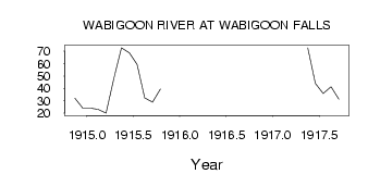
| PointID: | 4435 | Code: | 05QD001 | Latitude (decimal degrees): | 50.25 | Longitude (decimal degrees): | -93.91 | Drainage Area (km2): | 8080.00 | Source: | Hydat | Hydrological Zone: | Nelson | Name: | WABIGOON RIVER AT WABIGOON FALLS |
|---|
| Download | |
|---|---|
| Site Descriptor Information | Site Time Series Data |
| Link to all available data | |
| ID | Year | Jan | Feb | Mar | Apr | May | Jun | Jul | Aug | Sep | Oct | Nov | Dec |
|---|---|---|---|---|---|---|---|---|---|---|---|---|---|
| 4435 | 1914 | 32.00 | 24.00 | ||||||||||
| 4435 | 1915 | 24.00 | 23.00 | 20.00 | 48.00 | 72.70 | 68.80 | 59.20 | 32.30 | 28.90 | 39.50 | ||
| 4435 | 1917 | 72.80 | 44.00 | 35.80 | 41.40 | 31.30 |
 Return to R-Arctic Net Home Page