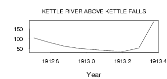
| PointID: | 4384 | Code: | 05PA001 | Latitude (decimal degrees): | 48.49 | Longitude (decimal degrees): | -92.64 | Drainage Area (km2): | 19300.00 | Source: | Hydat | Hydrological Zone: | Nelson | Name: | KETTLE RIVER ABOVE KETTLE FALLS |
|---|
| Download | |
|---|---|
| Site Descriptor Information | Site Time Series Data |
| Link to all available data | |
| ID | Year | Jan | Feb | Mar | Apr | May | Jun | Jul | Aug | Sep | Oct | Nov | Dec |
|---|---|---|---|---|---|---|---|---|---|---|---|---|---|
| 4384 | 1912 | 104.00 | 82.10 | 63.00 | 51.00 | ||||||||
| 4384 | 1913 | 45.00 | 39.00 | 36.00 | 53.00 | 187.00 |
 Return to R-Arctic Net Home Page