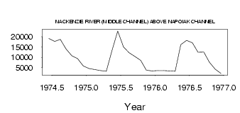
| PointID: | 3657 | Code: | 10LC008 | Latitude (decimal degrees): | 68.43 | Longitude (decimal degrees): | -134.11 | Drainage Area (km2): | Source: | Hydat | Hydrological Zone: | Mackenzie | Name: | MACKENZIE RIVER (MIDDLE CHANNEL) ABOVE NAPOIAK CHANNEL |
|---|
| Download | |
|---|---|
| Site Descriptor Information | Site Time Series Data |
| Link to all available data | |
| ID | Year | Jan | Feb | Mar | Apr | May | Jun | Jul | Aug | Sep | Oct | Nov | Dec |
|---|---|---|---|---|---|---|---|---|---|---|---|---|---|
| 3657 | 1974 | 19100.00 | 17700.00 | 18700.00 | 14000.00 | 10700.00 | 9370.00 | 5780.00 | |||||
| 3657 | 1975 | 4550.00 | 4090.00 | 3630.00 | 3260.00 | 13200.00 | 22700.00 | 15000.00 | 12200.00 | 10400.00 | 8490.00 | 3800.00 | 3430.00 |
| 3657 | 1976 | 3600.00 | 3600.00 | 3400.00 | 3240.00 | 16100.00 | 18200.00 | 17000.00 | 12400.00 | 12500.00 | 7630.00 | 4220.00 | 2180.00 |
 Return to R-Arctic Net Home Page