| PointID: | 3616 | Code: | 10FB006 | Latitude (decimal degrees): | 61.81 | Longitude (decimal degrees): | -120.79 | Drainage Area (km2): | Source: | Hydat | Hydrological Zone: | Mackenzie | Name: | MACKENZIE RIVER AT STRONG POINT |
|---|
| Download | |
|---|---|
| Site Descriptor Information | Site Time Series Data |
| Link to all available data | |
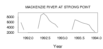
| ID | Year | Jan | Feb | Mar | Apr | May | Jun | Jul | Aug | Sep | Oct | Nov | Dec |
|---|---|---|---|---|---|---|---|---|---|---|---|---|---|
| 3616 | 1991 | 5840.00 | 3020.00 | ||||||||||
| 3616 | 1992 | 3530.00 | 8640.00 | 9350.00 | 8320.00 | 6590.00 | 5720.00 | 5170.00 | 3930.00 | ||||
| 3616 | 1993 | 3080.00 | 6930.00 | 6530.00 | 5970.00 | 5580.00 | 5320.00 | 4880.00 | 3200.00 | 2200.00 |
 Return to R-Arctic Net Home Page