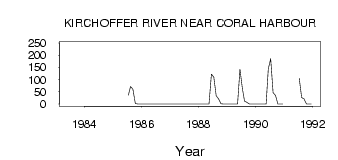
| PointID: | 3552 | Code: | 06PA001 | Latitude (decimal degrees): | 64.12 | Longitude (decimal degrees): | -83.43 | Drainage Area (km2): | 3160.00 | Source: | Hydat | Hydrological Zone: | Northwest Hudson Bay | Name: | KIRCHOFFER RIVER NEAR CORAL HARBOUR |
|---|
| Download | |
|---|---|
| Site Descriptor Information | Site Time Series Data |
| Link to all available data | |
| ID | Year | Jan | Feb | Mar | Apr | May | Jun | Jul | Aug | Sep | Oct | Nov | Dec |
|---|---|---|---|---|---|---|---|---|---|---|---|---|---|
| 3552 | 1983 | 246.00 | |||||||||||
| 3552 | 1985 | 0.00 | 36.80 | 71.80 | 60.10 | 2.68 | 0.00 | 0.00 | |||||
| 3552 | 1988 | 0.00 | 0.00 | 0.00 | 0.00 | 0.00 | 122.00 | 110.00 | 33.50 | 21.40 | 1.33 | 0.00 | 0.00 |
| 3552 | 1989 | 0.00 | 0.00 | 0.00 | 0.00 | 0.00 | 143.00 | 63.70 | 12.20 | 6.94 | 0.24 | 0.00 | 0.00 |
| 3552 | 1990 | 0.00 | 0.00 | 0.00 | 0.00 | 0.05 | 144.00 | 186.00 | 46.80 | 36.10 | 0.20 | 0.00 | 0.00 |
| 3552 | 1991 | 105.00 | 27.00 | 20.50 | 0.11 | 0.00 | 0.00 |
 Return to R-Arctic Net Home Page