| PointID: | 3547 | Code: | 06OA002 | Latitude (decimal degrees): | 63.64 | Longitude (decimal degrees): | -90.70 | Drainage Area (km2): | 0.15 | Source: | Hydat | Hydrological Zone: | Northwest Hudson Bay | Name: | MEADOW CREEK ABOVE SAQVAQJUAC INLET |
|---|
| Download | |
|---|---|
| Site Descriptor Information | Site Time Series Data |
| Link to all available data | |
| ID | Year | Jan | Feb | Mar | Apr | May | Jun | Jul | Aug | Sep | Oct | Nov | Dec |
|---|---|---|---|---|---|---|---|---|---|---|---|---|---|
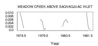
| 3547 | 1978 | 0.01 | 6.0e-03 | 1.0e-03 | |||||||||
| 3547 | 1979 | 6.0e-03 | 5.0e-03 | 0.00 | 1.0e-03 | ||||||||
| 3547 | 1980 | 2.0e-03 | 5.0e-03 | 6.0e-03 | 4.0e-03 | ||||||||
| 3547 | 1981 | 0.01 | 1.0e-03 | 0.00 |
 Return to R-Arctic Net Home Page