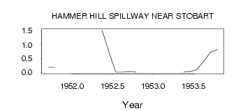
| PointID: | 333 | Code: | 05BM011 | Latitude (decimal degrees): | 50.90 | Longitude (decimal degrees): | -113.15 | Drainage Area (km2): | Source: | Hydat | Hydrological Zone: | Nelson | Name: | HAMMER HILL SPILLWAY NEAR STOBART |
|---|
| Download | |
|---|---|
| Site Descriptor Information | Site Time Series Data |
| Link to all available data | |
| ID | Year | Jan | Feb | Mar | Apr | May | Jun | Jul | Aug | Sep | Oct | Nov | Dec |
|---|---|---|---|---|---|---|---|---|---|---|---|---|---|
| 333 | 1951 | 0.18 | 0.18 | ||||||||||
| 333 | 1952 | 1.51 | 0.74 | 3.0e-03 | 3.0e-03 | 0.02 | 3.0e-03 | ||||||
| 333 | 1953 | 6.0e-03 | 0.02 | 0.10 | 0.40 | 0.72 | 0.82 |
 Return to R-Arctic Net Home Page