| PointID: | 32 | Code: | 05AB014 | Latitude (decimal degrees): | 49.73 | Longitude (decimal degrees): | -113.85 | Drainage Area (km2): | 53.09 | Source: | Hydat | Hydrological Zone: | Nelson | Name: | FIVE MILE CREEK NEAR SPRING POINT |
|---|
| Download | |
|---|---|
| Site Descriptor Information | Site Time Series Data |
| Link to all available data | |
| ID | Year | Jan | Feb | Mar | Apr | May | Jun | Jul | Aug | Sep | Oct | Nov | Dec |
|---|---|---|---|---|---|---|---|---|---|---|---|---|---|
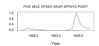
| 32 | 1922 | 0.00 | 0.00 | 0.13 | 0.04 | 0.05 | 0.01 | 7.0e-03 | 8.0e-03 | ||||
| 32 | 1923 | 0.00 | 0.00 | 0.11 | 1.21 | 0.46 | 0.20 | 0.10 | 0.05 |
 Return to R-Arctic Net Home Page