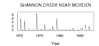
| PointID: | 3033 | Code: | 05OF021 | Latitude (decimal degrees): | 49.26 | Longitude (decimal degrees): | -97.97 | Drainage Area (km2): | 261.00 | Source: | Hydat | Hydrological Zone: | Nelson | Name: | SHANNON CREEK NEAR MORDEN |
|---|
| Download | |
|---|---|
| Site Descriptor Information | Site Time Series Data |
| Link to all available data | |
| ID | Year | Jan | Feb | Mar | Apr | May | Jun | Jul | Aug | Sep | Oct | Nov | Dec |
|---|---|---|---|---|---|---|---|---|---|---|---|---|---|
| 3033 | 1970 | 0.00 | 6.00 | 4.72 | 0.48 | 0.16 | 0.02 | 0.02 | 0.02 | ||||
| 3033 | 1971 | 0.00 | 5.00 | 0.42 | 0.32 | 0.07 | 0.01 | 0.01 | 0.13 | ||||
| 3033 | 1972 | 1.00 | 1.00 | 0.55 | 0.08 | 2.0e-03 | 6.0e-03 | 0.00 | 0.00 | ||||
| 3033 | 1973 | 0.00 | 0.00 | 5.0e-03 | 0.00 | 3.0e-03 | 0.00 | 0.00 | 1.0e-03 | ||||
| 3033 | 1974 | 0.00 | 9.00 | 6.14 | 0.79 | 0.06 | 1.0e-03 | 1.0e-03 | 4.0e-03 | ||||
| 3033 | 1975 | 0.00 | 0.00 | 0.38 | 0.38 | 0.07 | 0.00 | 0.00 | 0.00 | ||||
| 3033 | 1976 | 0.00 | 3.00 | 0.21 | 0.06 | 2.0e-03 | 0.00 | 0.00 | 0.00 | ||||
| 3033 | 1977 | 0.00 | 0.00 | 0.16 | 0.07 | 0.00 | 0.00 | 0.32 | 0.02 | ||||
| 3033 | 1978 | 0.00 | 2.00 | 0.52 | 0.38 | 0.06 | 0.01 | 0.08 | 0.00 | ||||
| 3033 | 1979 | 0.00 | 6.00 | 2.85 | 0.92 | 0.22 | 0.00 | 0.00 | 0.00 | ||||
| 3033 | 1980 | 0.00 | 0.00 | 1.0e-03 | 0.00 | 0.01 | 0.00 | 0.00 | 0.00 | ||||
| 3033 | 1981 | 0.00 | 0.00 | 0.00 | 0.01 | 9.0e-03 | 0.00 | 0.00 | 0.00 | 0.00 | |||
| 3033 | 1982 | 0.00 | 0.00 | 3.0e-03 | 0.06 | 0.00 | 0.00 | 0.00 | 0.04 | ||||
| 3033 | 1983 | 0.00 | 1.00 | 0.15 | 0.07 | 0.04 | 0.00 | 0.00 | 0.00 | ||||
| 3033 | 1984 | 0.00 | 0.00 | 0.11 | 1.0e-03 | 0.00 | 0.00 | 0.00 | 0.00 | ||||
| 3033 | 1985 | 1.00 | 0.00 | 0.04 | 0.04 | 0.02 | 1.15 | 0.21 | 0.13 | ||||
| 3033 | 1986 | 1.00 | 1.00 | 2.66 | 0.20 | 0.07 | 9.0e-03 | 0.00 | 0.00 | ||||
| 3033 | 1987 | 0.00 | 2.00 | 0.01 | 9.0e-03 | 0.01 | 0.01 | 0.00 | 0.00 |
 Return to R-Arctic Net Home Page