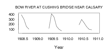
| PointID: | 281 | Code: | 05BH002 | Latitude (decimal degrees): | 51.03 | Longitude (decimal degrees): | -114.01 | Drainage Area (km2): | 10100.00 | Source: | Hydat | Hydrological Zone: | Nelson | Name: | BOW RIVER AT CUSHING BRIDGE NEAR CALGARY |
|---|
| Download | |
|---|---|
| Site Descriptor Information | Site Time Series Data |
| Link to all available data | |
| ID | Year | Jan | Feb | Mar | Apr | May | Jun | Jul | Aug | Sep | Oct | Nov | Dec |
|---|---|---|---|---|---|---|---|---|---|---|---|---|---|
| 281 | 1908 | 387.00 | 300.00 | 154.00 | 102.00 | ||||||||
| 281 | 1909 | 115.00 | 409.00 | 343.00 | 158.00 | 98.30 | 67.30 | ||||||
| 281 | 1910 | 189.00 | 295.00 | 225.00 | 150.00 | 97.50 | 87.60 | 34.00 |
 Return to R-Arctic Net Home Page