| PointID: | 2778 | Code: | 10CD002 | Latitude (decimal degrees): | 58.24 | Longitude (decimal degrees): | -122.80 | Drainage Area (km2): | 60.59 | Source: | Hydat | Hydrological Zone: | Mackenzie | Name: | PARKER CREEK NEAR THE MOUTH |
|---|
| Download | |
|---|---|
| Site Descriptor Information | Site Time Series Data |
| Link to all available data | |
| ID | Year | Jan | Feb | Mar | Apr | May | Jun | Jul | Aug | Sep | Oct | Nov | Dec |
|---|---|---|---|---|---|---|---|---|---|---|---|---|---|
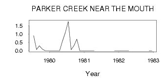
| 2778 | 1979 | 0.91 | 0.07 | 0.30 | 0.10 | 0.00 | 0.00 | ||||||
| 2778 | 1980 | 0.00 | 0.00 | 0.00 | 0.00 | 0.57 | 1.10 | 1.76 | 0.06 | 0.31 | 0.70 | 0.00 | 0.00 |
| 2778 | 1981 | 0.00 | 0.00 | 0.00 | 0.00 | 0.00 | 0.00 | ||||||
| 2778 | 1982 | 0.00 | 0.00 | 0.00 | 0.00 | 0.00 | 0.00 |
 Return to R-Arctic Net Home Page