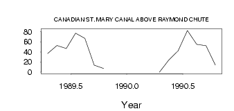
| PointID: | 170 | Code: | 05AF032 | Latitude (decimal degrees): | 49.40 | Longitude (decimal degrees): | -112.61 | Drainage Area (km2): | Source: | Hydat | Hydrological Zone: | Nelson | Name: | CANADIAN ST. MARY CANAL ABOVE RAYMOND CHUTE |
|---|
| Download | |
|---|---|
| Site Descriptor Information | Site Time Series Data |
| Link to all available data | |
| ID | Year | Jan | Feb | Mar | Apr | May | Jun | Jul | Aug | Sep | Oct | Nov | Dec |
|---|---|---|---|---|---|---|---|---|---|---|---|---|---|
| 170 | 1989 | 37.00 | 52.50 | 46.70 | 77.10 | 66.80 | 13.80 | 7.20 | |||||
| 170 | 1990 | 0.00 | 24.10 | 42.20 | 82.30 | 54.90 | 52.20 | 14.10 |
 Return to R-Arctic Net Home Page