|
|
|||||||||||||||||
| Point ID: 98 | Downloads | Plots | Site Data | Code: 05AD020 |
|
|
|||||||||||||||||
| Download | |
|---|---|
| Site Descriptor Information | Site Time Series Data |
| Link to all available data | |
| View: | Time Series | All |
| Units: | mm |
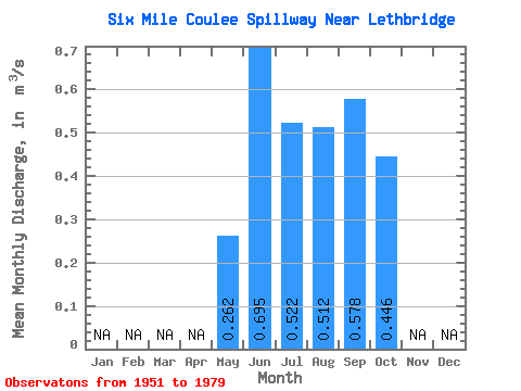
| Statistic | Jan | Feb | Mar | Apr | May | Jun | Jul | Aug | Sep | Oct | Nov | Dec | Annual |
|---|---|---|---|---|---|---|---|---|---|---|---|---|---|
| Mean | 0.26 | 0.69 | 0.52 | 0.51 | 0.58 | 0.45 | |||||||
| Standard Deviation | 0.35 | 1.09 | 0.63 | 0.65 | 0.99 | 0.74 | |||||||
| Min | 0.01 | 0.02 | 0.03 | 0.00 | 0.00 | 0.00 | |||||||
| Max | 1.27 | 3.75 | 2.76 | 2.39 | 2.82 | 2.12 | |||||||
| Coefficient of Variation | 1.32 | 1.56 | 1.20 | 1.28 | 1.71 | 1.65 |
 Return to R-Arctic Net Home Page