|
|
|||||||||||||||||
| Point ID: 9730 | Downloads | Plots | Site Data | Code: 05059500 |
|
|
|||||||||||||||||
| Download | |
|---|---|
| Site Descriptor Information | Site Time Series Data |
| Link to all available data | |
| View: | Time Series | All |
| Units: | mm |
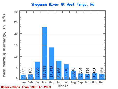
| Statistic | Jan | Feb | Mar | Apr | May | Jun | Jul | Aug | Sep | Oct | Nov | Dec | Annual |
|---|---|---|---|---|---|---|---|---|---|---|---|---|---|
| Mean | 2.00 | 2.18 | 7.83 | 22.78 | 13.98 | 8.17 | 6.72 | 3.85 | 2.59 | 2.37 | 2.90 | 2.45 | 6.52 |
| Standard Deviation | 1.80 | 1.95 | 8.63 | 20.42 | 17.25 | 7.98 | 8.49 | 7.44 | 3.43 | 2.70 | 3.44 | 2.55 | 5.28 |
| Min | 0.18 | 0.15 | 0.19 | 1.84 | 1.53 | 0.71 | 0.42 | 0.21 | 0.21 | 0.28 | 0.35 | 0.21 | 1.05 |
| Max | 7.82 | 9.06 | 33.53 | 93.78 | 91.61 | 50.55 | 38.88 | 62.81 | 17.23 | 20.20 | 19.45 | 13.25 | 22.42 |
| Coefficient of Variation | 0.90 | 0.89 | 1.10 | 0.90 | 1.23 | 0.98 | 1.26 | 1.93 | 1.32 | 1.14 | 1.19 | 1.04 | 0.81 |
 Return to R-Arctic Net Home Page