|
|
|||||||||||||||||
| Point ID: 9727 | Downloads | Plots | Site Data | Code: 05133500 |
|
|
|||||||||||||||||
| Download | |
|---|---|
| Site Descriptor Information | Site Time Series Data |
| Link to all available data | |
| View: | Time Series | All |
| Units: | mm |
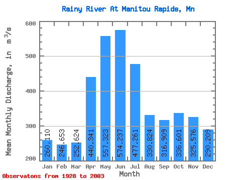
| Statistic | Jan | Feb | Mar | Apr | May | Jun | Jul | Aug | Sep | Oct | Nov | Dec | Annual |
|---|---|---|---|---|---|---|---|---|---|---|---|---|---|
| Mean | 260.11 | 246.65 | 252.62 | 440.34 | 557.32 | 574.24 | 477.26 | 330.82 | 316.91 | 336.60 | 325.58 | 290.21 | 369.99 |
| Standard Deviation | 90.45 | 72.97 | 72.00 | 187.23 | 311.14 | 329.51 | 255.25 | 186.09 | 168.97 | 210.67 | 194.10 | 141.30 | 112.58 |
| Min | 82.12 | 88.59 | 82.85 | 123.97 | 116.28 | 104.10 | 98.63 | 96.90 | 112.41 | 133.88 | 107.50 | 90.32 | 131.22 |
| Max | 521.85 | 488.26 | 471.06 | 1078.97 | 1497.32 | 1401.21 | 1358.39 | 954.37 | 867.16 | 1200.91 | 1055.65 | 787.03 | 685.46 |
| Coefficient of Variation | 0.35 | 0.30 | 0.28 | 0.42 | 0.56 | 0.57 | 0.54 | 0.56 | 0.53 | 0.63 | 0.60 | 0.49 | 0.30 |
 Return to R-Arctic Net Home Page