|
|
|||||||||||||||||
| Point ID: 9724 | Downloads | Plots | Site Data | Code: 05046000 |
|
|
|||||||||||||||||
| Download | |
|---|---|
| Site Descriptor Information | Site Time Series Data |
| Link to all available data | |
| View: | Time Series | All |
| Units: | mm |
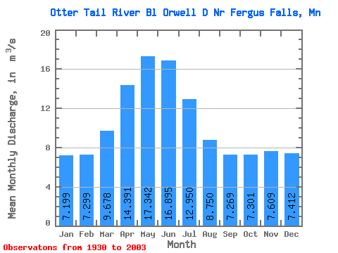
| Statistic | Jan | Feb | Mar | Apr | May | Jun | Jul | Aug | Sep | Oct | Nov | Dec | Annual |
|---|---|---|---|---|---|---|---|---|---|---|---|---|---|
| Mean | 7.20 | 7.30 | 9.68 | 14.39 | 17.34 | 16.89 | 12.95 | 8.75 | 7.27 | 7.30 | 7.61 | 7.41 | 10.35 |
| Standard Deviation | 5.12 | 4.87 | 5.28 | 7.83 | 9.99 | 10.57 | 8.80 | 7.17 | 6.24 | 5.93 | 5.94 | 5.58 | 5.88 |
| Min | 0.43 | 0.31 | 0.67 | 1.12 | 0.40 | 0.40 | 0.36 | 0.33 | 0.23 | 0.26 | 0.24 | 0.23 | 0.53 |
| Max | 20.86 | 21.02 | 22.22 | 33.96 | 40.42 | 40.84 | 35.28 | 30.58 | 29.07 | 27.54 | 23.52 | 20.96 | 23.66 |
| Coefficient of Variation | 0.71 | 0.67 | 0.55 | 0.54 | 0.58 | 0.62 | 0.68 | 0.82 | 0.86 | 0.81 | 0.78 | 0.75 | 0.57 |
 Return to R-Arctic Net Home Page