|
|
|||||||||||||||||
| Point ID: 9711 | Downloads | Plots | Site Data | Code: 05120000 |
|
|
|||||||||||||||||
| Download | |
|---|---|
| Site Descriptor Information | Site Time Series Data |
| Link to all available data | |
| View: | Time Series | All |
| Units: | mm |
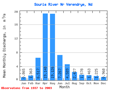
| Statistic | Jan | Feb | Mar | Apr | May | Jun | Jul | Aug | Sep | Oct | Nov | Dec | Annual |
|---|---|---|---|---|---|---|---|---|---|---|---|---|---|
| Mean | 0.86 | 1.36 | 6.52 | 19.15 | 19.13 | 7.27 | 4.59 | 2.43 | 1.58 | 1.46 | 1.23 | 0.97 | 5.67 |
| Standard Deviation | 1.04 | 2.01 | 8.05 | 27.39 | 31.84 | 10.70 | 6.80 | 2.96 | 1.79 | 1.43 | 1.11 | 1.05 | 6.38 |
| Min | 0.01 | 0.01 | 0.06 | 0.33 | 0.19 | 0.07 | 0.02 | 0.01 | 0.00 | 0.04 | 0.03 | 0.03 | 0.46 |
| Max | 4.84 | 7.85 | 34.24 | 177.84 | 139.25 | 60.08 | 45.28 | 14.51 | 10.29 | 6.38 | 4.78 | 4.54 | 32.83 |
| Coefficient of Variation | 1.21 | 1.47 | 1.23 | 1.43 | 1.67 | 1.47 | 1.48 | 1.22 | 1.13 | 0.98 | 0.91 | 1.08 | 1.12 |
 Return to R-Arctic Net Home Page