|
|
|||||||||||||||||
| Point ID: 9706 | Downloads | Plots | Site Data | Code: 05130500 |
|
|
|||||||||||||||||
| Download | |
|---|---|
| Site Descriptor Information | Site Time Series Data |
| Link to all available data | |
| View: | Time Series | All |
| Units: | mm |
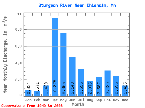
| Statistic | Jan | Feb | Mar | Apr | May | Jun | Jul | Aug | Sep | Oct | Nov | Dec | Annual |
|---|---|---|---|---|---|---|---|---|---|---|---|---|---|
| Mean | 0.83 | 0.67 | 1.43 | 10.28 | 8.37 | 5.14 | 3.56 | 2.08 | 2.59 | 3.42 | 2.70 | 1.43 | 3.57 |
| Standard Deviation | 0.40 | 0.29 | 1.52 | 5.22 | 5.71 | 2.94 | 3.29 | 1.65 | 2.23 | 3.01 | 1.68 | 0.81 | 0.93 |
| Min | 0.11 | 0.13 | 0.28 | 1.16 | 0.65 | 0.42 | 0.17 | 0.36 | 0.13 | 0.22 | 0.25 | 0.14 | 1.74 |
| Max | 1.87 | 1.35 | 9.54 | 24.58 | 41.07 | 14.94 | 17.63 | 7.58 | 12.02 | 17.00 | 7.47 | 3.83 | 5.44 |
| Coefficient of Variation | 0.48 | 0.43 | 1.06 | 0.51 | 0.68 | 0.57 | 0.92 | 0.79 | 0.86 | 0.88 | 0.62 | 0.57 | 0.26 |
 Return to R-Arctic Net Home Page