|
|
|||||||||||||||||
| Point ID: 9702 | Downloads | Plots | Site Data | Code: 05085000 |
|
|
|||||||||||||||||
| Download | |
|---|---|
| Site Descriptor Information | Site Time Series Data |
| Link to all available data | |
| View: | Time Series | All |
| Units: | mm |
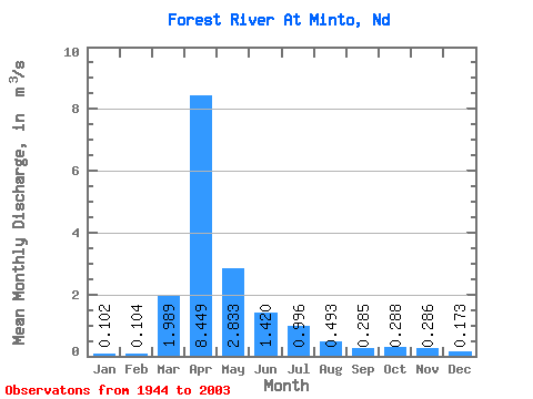
| Statistic | Jan | Feb | Mar | Apr | May | Jun | Jul | Aug | Sep | Oct | Nov | Dec | Annual |
|---|---|---|---|---|---|---|---|---|---|---|---|---|---|
| Mean | 0.10 | 0.10 | 1.99 | 8.45 | 2.83 | 1.42 | 1.00 | 0.49 | 0.28 | 0.29 | 0.29 | 0.17 | 1.47 |
| Standard Deviation | 0.11 | 0.20 | 2.81 | 9.50 | 5.97 | 1.61 | 1.58 | 1.25 | 0.38 | 0.25 | 0.18 | 0.13 | 1.33 |
| Min | 0.00 | 0.00 | 0.00 | 0.50 | 0.30 | 0.12 | 0.05 | 0.00 | 0.00 | 0.00 | 0.03 | 0.01 | 0.12 |
| Max | 0.45 | 1.42 | 12.41 | 44.54 | 42.91 | 7.55 | 9.87 | 9.28 | 1.95 | 1.67 | 0.92 | 0.59 | 7.58 |
| Coefficient of Variation | 1.08 | 1.98 | 1.41 | 1.12 | 2.11 | 1.14 | 1.59 | 2.53 | 1.34 | 0.88 | 0.61 | 0.77 | 0.90 |
 Return to R-Arctic Net Home Page