|
|
|||||||||||||||||
| Point ID: 9699 | Downloads | Plots | Site Data | Code: 05064000 |
|
|
|||||||||||||||||
| Download | |
|---|---|
| Site Descriptor Information | Site Time Series Data |
| Link to all available data | |
| View: | Time Series | All |
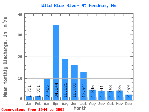
| Units: | mm |
| Statistic | Jan | Feb | Mar | Apr | May | Jun | Jul | Aug | Sep | Oct | Nov | Dec | Annual |
|---|---|---|---|---|---|---|---|---|---|---|---|---|---|
| Mean | 1.79 | 1.99 | 9.46 | 34.64 | 18.82 | 16.01 | 12.94 | 4.85 | 4.04 | 4.16 | 4.33 | 2.50 | 9.47 |
| Standard Deviation | 1.45 | 2.92 | 11.16 | 30.20 | 15.24 | 19.37 | 18.75 | 7.94 | 6.45 | 4.65 | 5.78 | 2.17 | 6.26 |
| Min | 0.00 | 0.01 | 0.01 | 2.99 | 1.59 | 0.26 | 0.25 | 0.03 | 0.01 | 0.01 | 0.09 | 0.03 | 1.60 |
| Max | 6.95 | 21.72 | 42.05 | 144.85 | 60.52 | 119.71 | 94.09 | 51.91 | 37.62 | 21.07 | 36.96 | 11.04 | 26.07 |
| Coefficient of Variation | 0.81 | 1.47 | 1.18 | 0.87 | 0.81 | 1.21 | 1.45 | 1.64 | 1.60 | 1.12 | 1.33 | 0.87 | 0.66 |
 Return to R-Arctic Net Home Page