|
|
|||||||||||||||||
| Point ID: 9696 | Downloads | Plots | Site Data | Code: 05092000 |
|
|
|||||||||||||||||
| Download | |
|---|---|
| Site Descriptor Information | Site Time Series Data |
| Link to all available data | |
| View: | Time Series | All |
| Units: | mm |
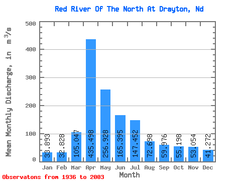
| Statistic | Jan | Feb | Mar | Apr | May | Jun | Jul | Aug | Sep | Oct | Nov | Dec | Annual |
|---|---|---|---|---|---|---|---|---|---|---|---|---|---|
| Mean | 33.89 | 32.83 | 105.05 | 435.50 | 256.93 | 165.40 | 147.45 | 72.70 | 59.98 | 55.20 | 53.05 | 41.27 | 125.12 |
| Standard Deviation | 18.89 | 17.72 | 120.96 | 338.56 | 289.30 | 130.80 | 146.97 | 85.94 | 57.56 | 38.67 | 50.51 | 27.47 | 75.63 |
| Min | 4.94 | 5.70 | 7.92 | 36.09 | 26.56 | 11.29 | 3.34 | 1.42 | 0.78 | 0.39 | 0.46 | 4.23 | 22.41 |
| Max | 75.86 | 73.57 | 621.08 | 1549.18 | 1667.68 | 663.18 | 799.63 | 611.00 | 343.80 | 147.08 | 335.31 | 118.03 | 326.74 |
| Coefficient of Variation | 0.56 | 0.54 | 1.15 | 0.78 | 1.13 | 0.79 | 1.00 | 1.18 | 0.96 | 0.70 | 0.95 | 0.67 | 0.60 |
 Return to R-Arctic Net Home Page