|
|
|||||||||||||||||
| Point ID: 9691 | Downloads | Plots | Site Data | Code: 05059000 |
|
|
|||||||||||||||||
| Download | |
|---|---|
| Site Descriptor Information | Site Time Series Data |
| Link to all available data | |
| View: | Time Series | All |
| Units: | mm |
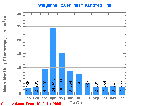
| Statistic | Jan | Feb | Mar | Apr | May | Jun | Jul | Aug | Sep | Oct | Nov | Dec | Annual |
|---|---|---|---|---|---|---|---|---|---|---|---|---|---|
| Mean | 2.44 | 2.70 | 9.42 | 24.49 | 15.20 | 8.66 | 7.66 | 4.29 | 2.89 | 2.75 | 3.32 | 2.91 | 7.28 |
| Standard Deviation | 1.61 | 1.93 | 9.59 | 24.39 | 19.43 | 8.66 | 8.94 | 8.60 | 3.39 | 2.88 | 3.20 | 2.40 | 5.51 |
| Min | 0.50 | 0.61 | 0.99 | 2.03 | 1.52 | 1.37 | 0.76 | 0.50 | 0.71 | 0.70 | 0.64 | 0.50 | 1.37 |
| Max | 6.85 | 8.97 | 35.58 | 112.06 | 86.44 | 54.87 | 41.51 | 63.17 | 14.95 | 19.61 | 16.66 | 11.33 | 21.86 |
| Coefficient of Variation | 0.66 | 0.71 | 1.02 | 1.00 | 1.28 | 1.00 | 1.17 | 2.01 | 1.17 | 1.05 | 0.96 | 0.83 | 0.76 |
 Return to R-Arctic Net Home Page