|
|
|||||||||||||||||
| Point ID: 9684 | Downloads | Plots | Site Data | Code: 05057200 |
|
|
|||||||||||||||||
| Download | |
|---|---|
| Site Descriptor Information | Site Time Series Data |
| Link to all available data | |
| View: | Time Series | All |
| Units: | mm |
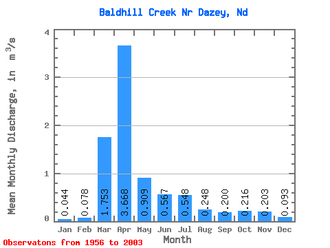
| Statistic | Jan | Feb | Mar | Apr | May | Jun | Jul | Aug | Sep | Oct | Nov | Dec | Annual |
|---|---|---|---|---|---|---|---|---|---|---|---|---|---|
| Mean | 0.04 | 0.08 | 1.75 | 3.67 | 0.91 | 0.57 | 0.55 | 0.25 | 0.20 | 0.22 | 0.20 | 0.09 | 0.72 |
| Standard Deviation | 0.05 | 0.15 | 2.57 | 5.87 | 1.31 | 0.84 | 1.19 | 0.60 | 0.36 | 0.45 | 0.31 | 0.09 | 0.81 |
| Min | 0.00 | 0.00 | 0.02 | 0.07 | 0.05 | 0.03 | 0.00 | 0.00 | 0.00 | 0.01 | 0.01 | 0.00 | 0.04 |
| Max | 0.21 | 0.97 | 13.46 | 29.45 | 6.22 | 5.11 | 7.74 | 3.77 | 1.66 | 3.01 | 1.55 | 0.46 | 3.29 |
| Coefficient of Variation | 1.17 | 1.95 | 1.47 | 1.60 | 1.44 | 1.49 | 2.17 | 2.41 | 1.82 | 2.07 | 1.52 | 1.02 | 1.12 |
 Return to R-Arctic Net Home Page