|
|
|||||||||||||||||
| Point ID: 9680 | Downloads | Plots | Site Data | Code: 05056400 |
|
|
|||||||||||||||||
| Download | |
|---|---|
| Site Descriptor Information | Site Time Series Data |
| Link to all available data | |
| View: | Time Series | All |
| Units: | mm |
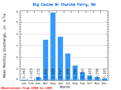
| Statistic | Jan | Feb | Mar | Apr | May | Jun | Jul | Aug | Sep | Oct | Nov | Dec | Annual |
|---|---|---|---|---|---|---|---|---|---|---|---|---|---|
| Mean | 0.06 | 0.03 | 0.27 | 3.50 | 5.83 | 3.75 | 2.31 | 1.29 | 0.70 | 0.42 | 0.30 | 0.16 | 1.34 |
| Standard Deviation | 0.21 | 0.09 | 0.67 | 6.06 | 10.60 | 6.79 | 3.87 | 2.39 | 1.70 | 1.14 | 0.76 | 0.47 | 1.91 |
| Min | 0.00 | 0.00 | 0.00 | 0.00 | 0.00 | 0.00 | 0.00 | 0.00 | 0.00 | 0.00 | 0.00 | 0.00 | 0.00 |
| Max | 1.11 | 0.50 | 3.71 | 32.56 | 56.60 | 29.15 | 16.80 | 9.72 | 9.41 | 7.19 | 4.80 | 2.69 | 7.80 |
| Coefficient of Variation | 3.39 | 3.21 | 2.45 | 1.73 | 1.82 | 1.81 | 1.68 | 1.85 | 2.43 | 2.69 | 2.56 | 2.87 | 1.43 |
 Return to R-Arctic Net Home Page