|
|
|||||||||||||||||
| Point ID: 9674 | Downloads | Plots | Site Data | Code: 05040500 |
|
|
|||||||||||||||||
| Download | |
|---|---|
| Site Descriptor Information | Site Time Series Data |
| Link to all available data | |
| View: | Time Series | All |
| Units: | mm |
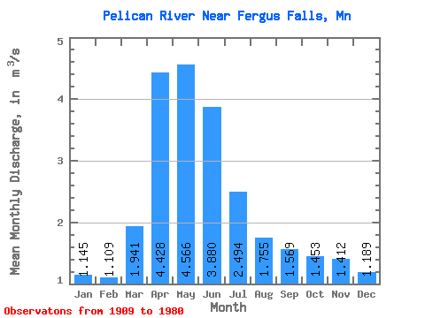
| Statistic | Jan | Feb | Mar | Apr | May | Jun | Jul | Aug | Sep | Oct | Nov | Dec | Annual |
|---|---|---|---|---|---|---|---|---|---|---|---|---|---|
| Mean | 1.15 | 1.11 | 1.94 | 4.43 | 4.57 | 3.88 | 2.49 | 1.75 | 1.57 | 1.45 | 1.41 | 1.19 | 2.24 |
| Standard Deviation | 1.07 | 0.98 | 1.41 | 2.03 | 2.16 | 2.35 | 1.73 | 1.33 | 1.22 | 1.11 | 1.09 | 1.07 | 0.91 |
| Min | 0.00 | 0.00 | 0.15 | 0.48 | 0.36 | 0.21 | 0.12 | 0.01 | 0.00 | 0.00 | 0.04 | 0.01 | 0.55 |
| Max | 3.54 | 3.31 | 5.27 | 9.05 | 8.77 | 10.08 | 7.52 | 5.07 | 5.35 | 4.90 | 4.01 | 3.75 | 4.09 |
| Coefficient of Variation | 0.94 | 0.89 | 0.73 | 0.46 | 0.47 | 0.60 | 0.69 | 0.76 | 0.78 | 0.77 | 0.78 | 0.90 | 0.41 |
 Return to R-Arctic Net Home Page