|
|
|||||||||||||||||
| Point ID: 9673 | Downloads | Plots | Site Data | Code: 05065500 |
|
|
|||||||||||||||||
| Download | |
|---|---|
| Site Descriptor Information | Site Time Series Data |
| Link to all available data | |
| View: | Time Series | All |
| Units: | mm |
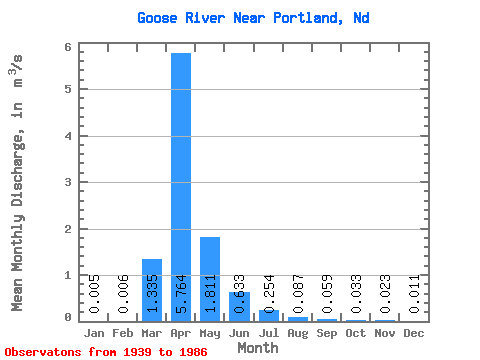
| Statistic | Jan | Feb | Mar | Apr | May | Jun | Jul | Aug | Sep | Oct | Nov | Dec | Annual |
|---|---|---|---|---|---|---|---|---|---|---|---|---|---|
| Mean | 0.01 | 0.01 | 1.33 | 5.76 | 1.81 | 0.63 | 0.25 | 0.09 | 0.06 | 0.03 | 0.02 | 0.01 | 0.83 |
| Standard Deviation | 0.01 | 0.02 | 2.25 | 7.20 | 6.09 | 0.73 | 0.36 | 0.26 | 0.16 | 0.07 | 0.05 | 0.02 | 1.12 |
| Min | 0.00 | 0.00 | 0.00 | 0.00 | 0.00 | 0.00 | 0.00 | 0.00 | 0.00 | 0.00 | 0.00 | 0.00 | 0.00 |
| Max | 0.05 | 0.11 | 11.54 | 30.60 | 39.35 | 2.92 | 1.49 | 1.29 | 0.85 | 0.29 | 0.20 | 0.08 | 6.04 |
| Coefficient of Variation | 2.22 | 2.93 | 1.69 | 1.25 | 3.36 | 1.16 | 1.41 | 2.97 | 2.75 | 2.25 | 1.95 | 2.04 | 1.35 |
 Return to R-Arctic Net Home Page