|
|
|||||||||||||||||
| Point ID: 9669 | Downloads | Plots | Site Data | Code: 05056200 |
|
|
|||||||||||||||||
| Download | |
|---|---|
| Site Descriptor Information | Site Time Series Data |
| Link to all available data | |
| View: | Time Series | All |
| Units: | mm |
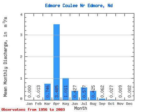
| Statistic | Jan | Feb | Mar | Apr | May | Jun | Jul | Aug | Sep | Oct | Nov | Dec | Annual |
|---|---|---|---|---|---|---|---|---|---|---|---|---|---|
| Mean | 0.00 | 0.01 | 0.75 | 3.48 | 1.01 | 0.43 | 0.58 | 0.42 | 0.06 | 0.03 | 0.01 | 0.00 | 0.37 |
| Standard Deviation | 0.00 | 0.06 | 1.46 | 3.53 | 1.87 | 1.04 | 1.50 | 1.81 | 0.21 | 0.07 | 0.03 | 0.01 | 0.39 |
| Min | 0.00 | 0.00 | 0.00 | 0.00 | 0.00 | 0.00 | 0.00 | 0.00 | 0.00 | 0.00 | 0.00 | 0.00 | 0.00 |
| Max | 0.00 | 0.33 | 6.57 | 14.97 | 8.74 | 5.32 | 8.67 | 12.37 | 1.28 | 0.28 | 0.16 | 0.03 | 1.35 |
| Coefficient of Variation | 5.08 | 1.96 | 1.01 | 1.85 | 2.43 | 2.59 | 4.24 | 3.37 | 2.46 | 3.54 | 3.63 | 1.05 |
 Return to R-Arctic Net Home Page