|
|
|||||||||||||||||
| Point ID: 9668 | Downloads | Plots | Site Data | Code: 05124480 |
|
|
|||||||||||||||||
| Download | |
|---|---|
| Site Descriptor Information | Site Time Series Data |
| Link to all available data | |
| View: | Time Series | All |
| Units: | mm |
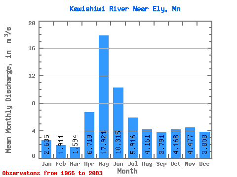
| Statistic | Jan | Feb | Mar | Apr | May | Jun | Jul | Aug | Sep | Oct | Nov | Dec | Annual |
|---|---|---|---|---|---|---|---|---|---|---|---|---|---|
| Mean | 2.63 | 1.91 | 1.59 | 6.72 | 17.92 | 10.31 | 5.92 | 4.16 | 3.79 | 4.17 | 4.48 | 3.81 | 5.71 |
| Standard Deviation | 1.22 | 0.69 | 0.43 | 4.95 | 8.22 | 5.87 | 3.04 | 3.77 | 4.27 | 4.79 | 4.22 | 2.57 | 1.54 |
| Min | 0.15 | 0.14 | 0.17 | 0.25 | 0.38 | 3.26 | 1.84 | 1.02 | 0.53 | 0.34 | 0.27 | 0.20 | 3.02 |
| Max | 4.61 | 3.02 | 2.41 | 22.23 | 32.08 | 30.29 | 14.81 | 21.46 | 19.77 | 24.96 | 19.36 | 9.78 | 9.70 |
| Coefficient of Variation | 0.46 | 0.36 | 0.27 | 0.74 | 0.46 | 0.57 | 0.51 | 0.91 | 1.13 | 1.15 | 0.94 | 0.68 | 0.27 |
 Return to R-Arctic Net Home Page