|
|
|||||||||||||||||
| Point ID: 9664 | Downloads | Plots | Site Data | Code: 05060000 |
|
|
|||||||||||||||||
| Download | |
|---|---|
| Site Descriptor Information | Site Time Series Data |
| Link to all available data | |
| View: | Time Series | All |
| Units: | mm |
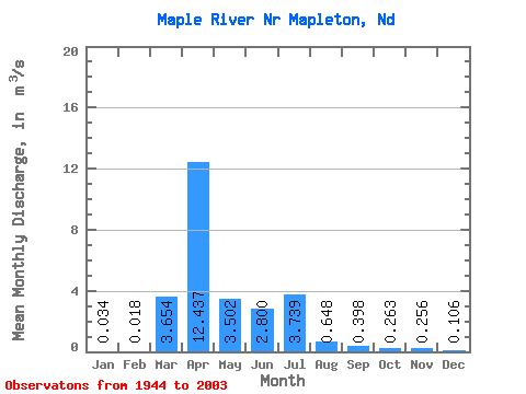
| Statistic | Jan | Feb | Mar | Apr | May | Jun | Jul | Aug | Sep | Oct | Nov | Dec | Annual |
|---|---|---|---|---|---|---|---|---|---|---|---|---|---|
| Mean | 0.03 | 0.02 | 3.65 | 12.44 | 3.50 | 2.80 | 3.74 | 0.65 | 0.40 | 0.26 | 0.26 | 0.11 | 1.80 |
| Standard Deviation | 0.04 | 0.03 | 7.04 | 14.00 | 4.22 | 4.26 | 11.43 | 1.29 | 0.48 | 0.39 | 0.23 | 0.09 | 1.61 |
| Min | 0.00 | 0.00 | 0.00 | 0.40 | 0.18 | 0.05 | 0.00 | 0.00 | 0.00 | 0.00 | 0.00 | 0.00 | 0.23 |
| Max | 0.12 | 0.14 | 29.45 | 48.38 | 17.55 | 20.29 | 67.25 | 7.57 | 1.86 | 1.45 | 1.03 | 0.35 | 5.58 |
| Coefficient of Variation | 1.08 | 1.73 | 1.93 | 1.13 | 1.21 | 1.52 | 3.06 | 1.99 | 1.21 | 1.50 | 0.91 | 0.87 | 0.89 |
 Return to R-Arctic Net Home Page