|
|
|||||||||||||||||
| Point ID: 9659 | Downloads | Plots | Site Data | Code: 05123900 |
|
|
|||||||||||||||||
| Download | |
|---|---|
| Site Descriptor Information | Site Time Series Data |
| Link to all available data | |
| View: | Time Series | All |
| Units: | mm |
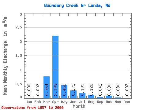
| Statistic | Jan | Feb | Mar | Apr | May | Jun | Jul | Aug | Sep | Oct | Nov | Dec | Annual |
|---|---|---|---|---|---|---|---|---|---|---|---|---|---|
| Mean | 0.00 | 0.00 | 0.76 | 2.20 | 0.47 | 0.27 | 0.19 | 0.12 | 0.04 | 0.09 | 0.03 | 0.00 | 0.36 |
| Standard Deviation | 0.00 | 0.01 | 1.38 | 3.79 | 1.18 | 0.72 | 0.44 | 0.31 | 0.12 | 0.28 | 0.09 | 0.01 | 0.42 |
| Min | 0.00 | 0.00 | 0.00 | 0.00 | 0.00 | 0.00 | 0.00 | 0.00 | 0.00 | 0.00 | 0.00 | 0.00 | 0.00 |
| Max | 0.00 | 0.06 | 4.73 | 15.22 | 6.80 | 3.81 | 2.30 | 1.48 | 0.63 | 1.31 | 0.32 | 0.04 | 1.48 |
| Coefficient of Variation | 4.90 | 4.37 | 1.80 | 1.72 | 2.52 | 2.65 | 2.30 | 2.58 | 2.75 | 3.07 | 2.95 | 4.22 | 1.17 |
 Return to R-Arctic Net Home Page