|
|
|||||||||||||||||
| Point ID: 9652 | Downloads | Plots | Site Data | Code: 05123100 |
|
|
|||||||||||||||||
| Download | |
|---|---|
| Site Descriptor Information | Site Time Series Data |
| Link to all available data | |
| View: | Time Series | All |
| Units: | mm |
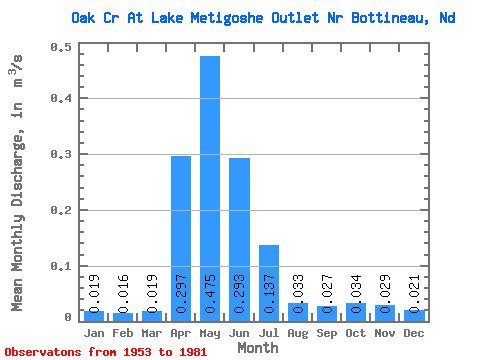
| Statistic | Jan | Feb | Mar | Apr | May | Jun | Jul | Aug | Sep | Oct | Nov | Dec | Annual |
|---|---|---|---|---|---|---|---|---|---|---|---|---|---|
| Mean | 0.02 | 0.02 | 0.02 | 0.30 | 0.47 | 0.29 | 0.14 | 0.03 | 0.03 | 0.03 | 0.03 | 0.02 | 0.12 |
| Standard Deviation | 0.06 | 0.05 | 0.06 | 0.59 | 0.80 | 0.38 | 0.21 | 0.07 | 0.09 | 0.12 | 0.09 | 0.05 | 0.17 |
| Min | 0.00 | 0.00 | 0.00 | 0.00 | 0.00 | 0.00 | 0.00 | 0.00 | 0.00 | 0.00 | 0.00 | 0.00 | 0.00 |
| Max | 0.31 | 0.26 | 0.26 | 2.58 | 3.45 | 1.51 | 0.70 | 0.33 | 0.42 | 0.63 | 0.42 | 0.21 | 0.68 |
| Coefficient of Variation | 3.33 | 3.29 | 2.83 | 1.97 | 1.68 | 1.31 | 1.56 | 2.10 | 3.32 | 3.55 | 2.92 | 2.56 | 1.41 |
 Return to R-Arctic Net Home Page