|
|
|||||||||||||||||
| Point ID: 9641 | Downloads | Plots | Site Data | Code: 05096500 |
|
|
|||||||||||||||||
| Download | |
|---|---|
| Site Descriptor Information | Site Time Series Data |
| Link to all available data | |
| View: | Time Series | All |
| Units: | mm |
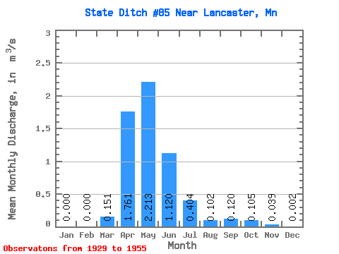
| Statistic | Jan | Feb | Mar | Apr | May | Jun | Jul | Aug | Sep | Oct | Nov | Dec | Annual |
|---|---|---|---|---|---|---|---|---|---|---|---|---|---|
| Mean | 0.00 | 0.00 | 0.15 | 1.76 | 2.21 | 1.12 | 0.40 | 0.10 | 0.12 | 0.10 | 0.04 | 0.00 | 0.49 |
| Standard Deviation | 0.00 | 0.00 | 0.40 | 1.82 | 4.29 | 1.84 | 1.04 | 0.22 | 0.28 | 0.28 | 0.07 | 0.01 | 0.73 |
| Min | 0.00 | 0.00 | 0.00 | 0.01 | 0.00 | 0.00 | 0.00 | 0.00 | 0.00 | 0.00 | 0.00 | 0.00 | 0.01 |
| Max | 0.00 | 0.00 | 1.56 | 6.95 | 20.23 | 8.41 | 4.95 | 0.96 | 1.13 | 1.23 | 0.22 | 0.03 | 3.21 |
| Coefficient of Variation | 4.69 | 2.62 | 1.03 | 1.94 | 1.65 | 2.56 | 2.19 | 2.32 | 2.63 | 1.88 | 2.87 | 1.47 |
 Return to R-Arctic Net Home Page